Lagarfljot - Lagarfoass
Scandinavia
| PointID: | 7720 |
Code: | II004 |
Latitude (decimal degrees): | 65.50 |
Longitude (decimal degrees): | -14.37 |
Drainage Area (km2): | 2800.00 |
Source: | SHI |
Hydrological Zone: | Scandinavia |
Name: | Lagarfljot - Lagarfoass |
Field Definitions
Site Time Series Plot:
Site Data File:
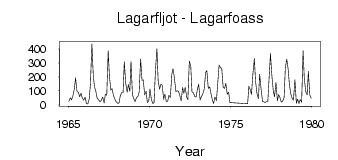
(Units: m3/s)
| ID | Year | Jan | Feb | Mar | Apr | May | Jun | Jul | Aug | Sep | Oct | Nov | Dec |
|---|
| 7720 | 1965 | 24.10 | 51.10 | 34.40 | 65.10 | 116.00 | 194.00 | 97.40 | 88.50 | 58.10 | 82.70 | 49.00 | 34.30 |
| 7720 | 1966 | 54.40 | 10.30 | 5.50 | 43.00 | 150.00 | 436.00 | 203.00 | 128.00 | 91.70 | 47.10 | 35.20 | 21.70 |
| 7720 | 1967 | 32.20 | 56.40 | 12.70 | 74.00 | 69.70 | 388.00 | 206.00 | 105.00 | 116.00 | 65.50 | 41.20 | 22.30 |
| 7720 | 1968 | 10.50 | 13.70 | 60.70 | 89.00 | 89.00 | 308.00 | 154.00 | 89.50 | 145.00 | 97.90 | 310.00 | 71.70 |
| 7720 | 1969 | 41.60 | 22.70 | 52.80 | 61.40 | 91.50 | 327.00 | 175.00 | 179.00 | 72.00 | 97.00 | 15.50 | 28.80 |
| 7720 | 1970 | 112.00 | 36.40 | 9.68 | 16.80 | 251.00 | 401.00 | 175.00 | 112.00 | 148.00 | 140.00 | 41.00 | 76.00 |
| 7720 | 1971 | 25.70 | 26.00 | 68.10 | 51.90 | 219.00 | 258.00 | 192.00 | 94.90 | 100.00 | 97.20 | 68.60 | 27.80 |
| 7720 | 1972 | 125.00 | 84.00 | 125.00 | 56.50 | 36.20 | 314.00 | 277.00 | 93.20 | 86.30 | 59.80 | 56.20 | 114.00 |
| 7720 | 1973 | 148.00 | 35.60 | 60.70 | 78.40 | 112.00 | 233.00 | 244.00 | 118.00 | 128.00 | 82.10 | 36.10 | 9.79 |
| 7720 | 1974 | 55.80 | 30.80 | 145.00 | 285.00 | 266.00 | 262.00 | 127.00 | 118.00 | 153.00 | 77.10 | 90.60 | 16.40 |
| 7720 | 1976 | 7.90 | 133.00 | 107.00 | 75.50 | 224.00 | 330.00 | 168.00 | 79.50 | 44.00 | 219.00 | 112.00 | 23.00 |
| 7720 | 1977 | 22.00 | 16.50 | 24.00 | 22.50 | 211.00 | 367.00 | 208.00 | 98.50 | 57.00 | 159.00 | 29.00 | 72.50 |
| 7720 | 1978 | 51.00 | 20.00 | 27.00 | 53.00 | 265.00 | 327.00 | 251.00 | 145.00 | 79.00 | 43.00 | 33.00 | 179.00 |
| 7720 | 1979 | 11.50 | 40.50 | 9.00 | 39.00 | 17.50 | 387.00 | 191.00 | 95.50 | 71.00 | 240.00 | 70.50 | 47.00 |
 Return to R-Arctic Net Home Page