YUKON R NR KALTAG AK
Yukon
| PointID: | 7708 |
Code: | 15565200 |
Latitude (decimal degrees): | 64.32 |
Longitude (decimal degrees): | -158.71 |
Drainage Area (km2): | 766640.75 |
Source: | AK |
Hydrological Zone: | Yukon |
Name: | YUKON R NR KALTAG AK |
Field Definitions
Site Time Series Plot:
Site Data File:
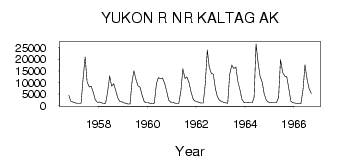
(Units: m3/s)
| ID | Year | Jan | Feb | Mar | Apr | May | Jun | Jul | Aug | Sep | Oct | Nov | Dec |
|---|
| 7708 | 1956 | | | | | | | | | | 4312.65 | 1840.59 | 1415.84 |
| 7708 | 1957 | 1160.99 | 962.77 | 906.13 | 948.61 | 11224.79 | 21022.42 | 10242.20 | 7968.36 | 8262.85 | 5586.91 | 2463.56 | 1300.87 |
| 7708 | 1958 | 1440.47 | 1202.33 | 847.80 | 962.77 | 5380.20 | 12779.39 | 8401.60 | 9313.41 | 6515.70 | 3202.63 | 1699.01 | 1585.74 |
| 7708 | 1959 | 1160.99 | 906.13 | 566.33 | 608.81 | 10120.44 | 15024.91 | 11179.49 | 8523.37 | 7815.44 | 4479.72 | 1642.37 | 1116.25 |
| 7708 | 1960 | 1093.31 | 935.30 | 848.65 | 934.45 | 9435.17 | 12037.49 | 11550.44 | 11853.43 | 9718.34 | 6405.27 | 2293.66 | 1414.99 |
| 7708 | 1961 | 1317.29 | 972.96 | 762.85 | 807.03 | 6371.29 | 15973.53 | 11666.54 | 12377.29 | 9797.62 | 5938.04 | 2690.10 | 1840.59 |
| 7708 | 1962 | 1614.06 | 1217.62 | 991.08 | 1019.40 | 8868.83 | 24049.49 | 16616.32 | 13804.46 | 13509.96 | 7053.72 | 3681.19 | 2123.76 |
| 7708 | 1963 | 1727.32 | 1359.20 | 1132.67 | 906.13 | 13345.72 | 17471.49 | 16049.98 | 16692.78 | 10482.89 | 6713.92 | 2661.78 | 1217.62 |
| 7708 | 1964 | 1160.99 | 1189.30 | 1104.35 | 1076.04 | 3525.44 | 26697.12 | 18199.23 | 12567.01 | 9942.04 | 4932.79 | 2194.55 | 1415.84 |
| 7708 | 1965 | 1217.62 | 1132.67 | 1076.04 | 1104.35 | 3502.79 | 19903.91 | 14328.32 | 12804.87 | 12331.98 | 7668.20 | 1713.16 | 1217.62 |
| 7708 | 1966 | 991.08 | 792.87 | 679.60 | 849.50 | 7104.69 | 17593.25 | 11179.49 | 7257.60 | 5179.15 | | | |
 Return to R-Arctic Net Home Page