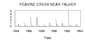
| PointID: | 770 | Code: | 07GH004 | Latitude (decimal degrees): | 55.62 | Longitude (decimal degrees): | -117.25 | Drainage Area (km2): | 537.00 | Source: | Hydat | Hydrological Zone: | Mackenzie | Name: | PEAVINE CREEK NEAR FALHER |
|---|
| Download | |
|---|---|
| Site Descriptor Information | Site Time Series Data |
| Link to all available data | |
| ID | Year | Jan | Feb | Mar | Apr | May | Jun | Jul | Aug | Sep | Oct | Nov | Dec |
|---|---|---|---|---|---|---|---|---|---|---|---|---|---|
| 770 | 1984 | 0.00 | 0.00 | 0.55 | 0.19 | 0.02 | 1.0e-03 | 1.0e-03 | 1.0e-03 | ||||
| 770 | 1985 | 1.00 | 1.00 | 0.02 | 1.0e-03 | 1.0e-03 | 2.0e-03 | 6.0e-03 | 0.14 | ||||
| 770 | 1986 | 3.00 | 3.00 | 0.20 | 7.0e-03 | 0.07 | 3.0e-03 | 1.0e-03 | 1.0e-03 | ||||
| 770 | 1987 | 0.00 | 3.00 | 0.01 | 1.0e-03 | 1.0e-03 | 1.0e-03 | 1.0e-03 | 1.0e-03 | ||||
| 770 | 1988 | 0.00 | 0.00 | 5.0e-03 | 0.36 | 0.15 | 2.0e-03 | 1.0e-03 | 2.0e-03 | ||||
| 770 | 1989 | 0.00 | 1.00 | 0.18 | 0.01 | 3.0e-03 | 3.0e-03 | 3.0e-03 | 0.11 | ||||
| 770 | 1990 | 2.00 | 2.00 | 0.06 | 0.46 | 1.0e-03 | 0.00 | 0.00 | 8.0e-03 | ||||
| 770 | 1991 | 0.00 | 1.00 | 0.05 | 0.03 | 5.0e-03 | 1.0e-03 | 2.0e-03 | 4.0e-03 | ||||
| 770 | 1992 | 5.00 | 0.00 | 0.04 | 0.09 | 1.0e-03 | 1.0e-03 | 1.0e-03 | 3.0e-03 | ||||
| 770 | 1993 | 0.00 | 0.00 | 3.0e-03 | 0.14 | 0.54 | 1.0e-03 | 1.0e-03 | 2.0e-03 |
 Return to R-Arctic Net Home Page