TANANA R AT BIG DELTA AK
Yukon
| PointID: | 7698 |
Code: | 15478000 |
Latitude (decimal degrees): | 64.15 |
Longitude (decimal degrees): | -145.85 |
Drainage Area (km2): | 34965.03 |
Source: | AK |
Hydrological Zone: | Yukon |
Name: | TANANA R AT BIG DELTA AK |
Field Definitions
Site Time Series Plot:
Site Data File:
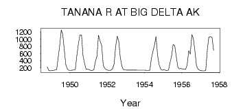
(Units: m3/s)
| ID | Year | Jan | Feb | Mar | Apr | May | Jun | Jul | Aug | Sep | Oct | Nov | Dec |
|---|
| 7698 | 1948 | | | | | | | | | | 223.92 | 132.23 | 118.47 |
| 7698 | 1949 | 128.16 | 125.41 | 144.33 | 150.22 | 479.12 | 797.68 | 1260.94 | 1134.65 | 672.80 | 279.00 | 161.74 | 130.17 |
| 7698 | 1950 | 130.25 | 134.50 | 142.71 | 148.40 | 518.19 | 871.30 | 1119.08 | 1124.17 | 540.85 | 315.16 | 158.09 | 168.54 |
| 7698 | 1951 | 150.07 | 129.66 | 125.86 | 152.74 | 390.20 | 533.77 | 1112.00 | 944.36 | 834.49 | 273.62 | 185.02 | 148.06 |
| 7698 | 1952 | 134.27 | 129.77 | 134.56 | 171.79 | 310.35 | 791.17 | 1084.81 | 942.66 | 504.03 | 242.42 | 150.92 | 141.13 |
| 7698 | 1954 | 135.75 | 131.78 | 128.78 | 132.80 | 462.13 | 670.25 | 840.72 | 1077.45 | 546.23 | 286.28 | 161.77 | 133.00 |
| 7698 | 1955 | 148.60 | 133.28 | 120.20 | 137.81 | 338.95 | 538.86 | 852.62 | 818.92 | 517.34 | 217.38 | 169.10 | 179.21 |
| 7698 | 1956 | 168.71 | 173.15 | 156.98 | 279.57 | 678.18 | 580.77 | 1132.39 | 1019.97 | 684.41 | 257.88 | 168.00 | 133.99 |
| 7698 | 1957 | 119.52 | 116.92 | 114.79 | 123.12 | 724.06 | 1064.99 | 1071.79 | 1060.18 | 689.23 | | | |
 Return to R-Arctic Net Home Page