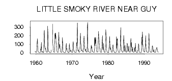
| PointID: | 769 | Code: | 07GH002 | Latitude (decimal degrees): | 55.45 | Longitude (decimal degrees): | -117.16 | Drainage Area (km2): | 11100.00 | Source: | Hydat | Hydrological Zone: | Mackenzie | Name: | LITTLE SMOKY RIVER NEAR GUY |
|---|
| Download | |
|---|---|
| Site Descriptor Information | Site Time Series Data |
| Link to all available data | |
| ID | Year | Jan | Feb | Mar | Apr | May | Jun | Jul | Aug | Sep | Oct | Nov | Dec |
|---|---|---|---|---|---|---|---|---|---|---|---|---|---|
| 769 | 1959 | 16.80 | 16.00 | 6.00 | |||||||||
| 769 | 1960 | 3.00 | 3.00 | 6.00 | 51.00 | 120.00 | 164.00 | 65.60 | 17.80 | 8.50 | 6.57 | 5.00 | 2.00 |
| 769 | 1961 | 2.00 | 2.00 | 3.00 | 13.00 | 48.20 | 30.10 | 120.00 | 19.10 | 4.55 | 13.90 | 14.00 | 5.00 |
| 769 | 1962 | 2.00 | 1.00 | 5.00 | 217.00 | 262.00 | 76.60 | 69.80 | 39.40 | 53.60 | 18.50 | 12.00 | 7.00 |
| 769 | 1963 | 7.00 | 5.00 | 8.00 | 310.00 | 217.00 | 50.40 | 17.60 | 13.70 | 10.30 | 10.10 | 1.00 | 1.00 |
| 769 | 1964 | 2.00 | 3.00 | 5.00 | 34.00 | 334.00 | 114.00 | 66.00 | 18.00 | 11.00 | |||
| 769 | 1965 | 7.00 | 6.00 | 6.00 | 226.00 | 228.00 | 160.00 | 229.00 | 118.00 | 110.00 | 42.30 | 15.00 | 10.00 |
| 769 | 1966 | 4.00 | 5.00 | 5.00 | 119.00 | 239.00 | 76.90 | 49.30 | 100.00 | 77.90 | 17.90 | 11.00 | 8.00 |
| 769 | 1967 | 4.00 | 4.00 | 5.00 | 60.00 | 177.00 | 99.90 | 18.60 | 10.70 | 5.28 | 5.40 | 3.00 | 1.00 |
| 769 | 1968 | 2.00 | 3.00 | 6.00 | 21.00 | 82.30 | 110.00 | 36.00 | 50.50 | 21.90 | 13.60 | 7.00 | 5.00 |
| 769 | 1969 | 2.00 | 1.00 | 2.00 | 108.00 | 73.70 | 17.90 | 13.80 | 19.10 | 32.10 | 21.30 | 12.00 | 7.00 |
| 769 | 1970 | 4.00 | 4.00 | 5.00 | 109.00 | 130.00 | 47.90 | 24.80 | 19.60 | 9.77 | 7.65 | 3.00 | 3.00 |
| 769 | 1971 | 3.00 | 3.00 | 4.00 | 117.00 | 79.80 | 210.00 | 347.00 | 47.10 | 20.20 | 35.70 | 12.00 | 12.00 |
| 769 | 1972 | 6.00 | 5.00 | 11.00 | 119.00 | 228.00 | 128.00 | 82.30 | 55.00 | 21.70 | 34.00 | 25.00 | 14.00 |
| 769 | 1973 | 8.00 | 7.00 | 7.00 | 126.00 | 194.00 | 125.00 | 46.70 | 47.10 | 24.10 | 40.60 | 19.00 | 11.00 |
| 769 | 1974 | 8.00 | 7.00 | 7.00 | 289.00 | 355.00 | 53.30 | 39.00 | 10.90 | 12.50 | 9.37 | 4.00 | 4.00 |
| 769 | 1975 | 4.00 | 4.00 | 4.00 | 39.00 | 89.00 | 53.80 | 71.80 | 18.40 | 22.40 | 11.00 | 12.00 | 6.00 |
| 769 | 1976 | 5.00 | 5.00 | 4.00 | 177.00 | 82.90 | 179.00 | 108.00 | 176.00 | 90.30 | 31.30 | 16.00 | 8.00 |
| 769 | 1977 | 7.00 | 8.00 | 8.00 | 137.00 | 248.00 | 173.00 | 143.00 | 68.60 | 50.40 | 50.50 | 12.00 | 7.00 |
| 769 | 1978 | 6.00 | 4.00 | 8.00 | 54.00 | 114.00 | 199.00 | 61.60 | 32.90 | 113.00 | 49.20 | 17.00 | 11.00 |
| 769 | 1979 | 6.00 | 4.00 | 6.00 | 66.00 | 269.00 | 229.00 | 208.00 | 38.90 | 14.50 | 11.00 | 3.00 | 3.00 |
| 769 | 1980 | 4.00 | 3.00 | 3.00 | 62.00 | 55.40 | 192.00 | 111.00 | 36.00 | 60.80 | 38.40 | 19.00 | 9.00 |
| 769 | 1981 | 7.00 | 6.00 | 10.00 | 77.00 | 92.40 | 91.70 | 27.50 | 25.00 | 5.70 | 6.64 | 5.00 | 1.00 |
| 769 | 1982 | 1.00 | 1.00 | 3.00 | 13.00 | 187.00 | 49.80 | 164.00 | 161.00 | 42.70 | 22.00 | 9.00 | 6.00 |
| 769 | 1983 | 4.00 | 4.00 | 5.00 | 19.00 | 35.50 | 133.00 | 293.00 | 90.50 | 35.60 | 21.40 | 19.00 | 9.00 |
| 769 | 1984 | 6.00 | 6.00 | 9.00 | 48.00 | 200.00 | 126.00 | 33.80 | 13.20 | 91.10 | 41.90 | 20.00 | 10.00 |
| 769 | 1985 | 7.00 | 5.00 | 9.00 | 112.00 | 106.00 | 53.50 | 25.50 | 13.00 | 62.10 | 79.90 | 21.00 | 9.00 |
| 769 | 1986 | 7.00 | 6.00 | 13.00 | 130.00 | 168.00 | 62.30 | 120.00 | 28.90 | 14.20 | 64.40 | 14.00 | 9.00 |
| 769 | 1987 | 7.00 | 6.00 | 6.00 | 61.00 | 43.40 | 27.10 | 12.50 | 110.00 | 37.20 | 13.30 | 7.00 | 3.00 |
| 769 | 1988 | 2.00 | 3.00 | 9.00 | 30.00 | 25.40 | 105.00 | 88.40 | 12.10 | 5.91 | 6.21 | 5.00 | 2.00 |
| 769 | 1989 | 1.00 | 2.00 | 3.00 | 29.00 | 181.00 | 89.40 | 243.00 | 165.00 | 53.80 | 26.40 | 21.00 | 15.00 |
| 769 | 1990 | 11.00 | 7.00 | 14.00 | 65.00 | 72.60 | 199.00 | 66.90 | 13.50 | 13.70 | 11.30 | 7.00 | 6.00 |
| 769 | 1991 | 5.00 | 4.00 | 6.00 | 137.00 | 227.00 | 74.20 | 41.40 | 21.00 | 10.00 | 7.78 | 9.00 | 6.00 |
| 769 | 1992 | 6.00 | 9.00 | 34.00 | 82.00 | 73.90 | 42.00 | 13.20 | 10.50 | 38.10 | 17.80 | 7.00 | 3.00 |
| 769 | 1993 | 3.00 | 3.00 | 6.00 | 37.00 | 38.70 | 49.50 | 64.00 | 44.70 | 33.80 | 11.00 | 8.00 | 5.00 |
| Other Close Sites | ||||||
|---|---|---|---|---|---|---|
| PointID | Latitude | Longitude | Drainage Area | Source | Name | |
| 768 | 55.37 | -116.92 | 10600.00 | Hydat | LITTLE SMOKY RIVER NEAR TRIANGLE | |
 Return to R-Arctic Net Home Page