KOBUK R NR KIANA AK
Yukon
| PointID: | 7688 |
Code: | 15744500 |
Latitude (decimal degrees): | 66.97 |
Longitude (decimal degrees): | -160.13 |
Drainage Area (km2): | 24656.67 |
Source: | AK |
Hydrological Zone: | Yukon |
Name: | KOBUK R NR KIANA AK |
Field Definitions
Site Time Series Plot:
Site Data File:
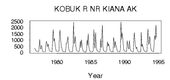
(Units: m3/s)
| ID | Year | Jan | Feb | Mar | Apr | May | Jun | Jul | Aug | Sep | Oct | Nov | Dec |
|---|
| 7688 | 1976 | | | | | | | | | 331.67 | 256.99 | 157.26 | 107.25 |
| 7688 | 1977 | 73.04 | 56.60 | 56.60 | 50.94 | 422.23 | 1052.19 | 327.71 | 265.25 | 577.03 | 423.93 | 98.68 | 64.09 |
| 7688 | 1978 | 55.12 | 52.94 | 49.94 | 46.77 | 706.93 | 891.73 | 682.31 | 447.42 | 687.69 | 349.50 | 148.37 | 113.11 |
| 7688 | 1979 | 95.56 | 72.87 | 55.60 | 56.88 | 1370.56 | 1839.78 | 903.90 | 1138.22 | 744.85 | 394.78 | 110.56 | 83.34 |
| 7688 | 1980 | 79.24 | 76.41 | 73.58 | 104.79 | 1327.27 | 1808.65 | 1135.67 | 488.74 | 433.27 | 175.00 | 77.82 | 60.70 |
| 7688 | 1981 | 56.60 | 50.94 | 48.11 | 49.89 | 747.40 | 730.70 | 945.22 | 1271.80 | 478.27 | 177.75 | 78.58 | 54.50 |
| 7688 | 1982 | 45.44 | 41.43 | 39.62 | 36.79 | 504.30 | 2435.78 | 710.61 | 820.13 | 1301.23 | 514.77 | 199.03 | 121.15 |
| 7688 | 1983 | 84.44 | 67.01 | 57.59 | 79.72 | 493.55 | 908.71 | 384.31 | 1023.32 | 676.37 | 253.59 | 113.20 | 72.67 |
| 7688 | 1984 | 50.77 | 37.66 | 31.58 | 28.30 | 192.72 | 1003.80 | 553.54 | 1507.54 | 520.15 | 239.64 | 86.59 | 61.26 |
| 7688 | 1985 | 54.13 | 49.12 | 43.80 | 40.55 | 187.06 | 1842.33 | 621.46 | 329.69 | 1606.87 | 703.25 | 230.56 | 132.92 |
| 7688 | 1986 | 91.46 | 66.70 | 50.03 | 39.53 | 75.13 | 1086.43 | 381.76 | 754.47 | 2212.77 | 449.40 | 167.33 | 107.90 |
| 7688 | 1987 | 84.53 | 73.58 | 65.00 | 59.91 | 255.06 | 856.35 | 497.23 | 697.87 | 532.32 | 309.60 | 114.04 | 66.64 |
| 7688 | 1988 | 52.86 | 47.23 | 45.28 | 51.70 | 1220.29 | 899.65 | 347.24 | 894.84 | 547.88 | 508.83 | 176.95 | 107.17 |
| 7688 | 1989 | 74.11 | 51.25 | 48.02 | 45.28 | 219.74 | 2462.38 | 1033.23 | 1585.64 | 1288.78 | 640.42 | 224.22 | 126.16 |
| 7688 | 1990 | 93.02 | 77.23 | 66.56 | 59.99 | 941.25 | 653.44 | 378.37 | 262.73 | 964.46 | 407.80 | 169.43 | 106.88 |
| 7688 | 1991 | 85.26 | 75.30 | 68.82 | 63.75 | 1365.19 | 1584.23 | 660.52 | 474.59 | 301.39 | 417.99 | 167.16 | 93.84 |
| 7688 | 1992 | 60.08 | 47.82 | 42.45 | 39.62 | 46.27 | 1650.73 | 455.06 | 681.46 | 457.61 | 265.85 | 148.77 | 98.59 |
| 7688 | 1993 | 75.67 | 63.08 | 54.95 | 51.13 | 1216.61 | 1902.04 | 646.93 | 770.32 | 1308.87 | 845.32 | 312.71 | 172.54 |
| 7688 | 1994 | 112.20 | 81.16 | 68.74 | 65.09 | 947.20 | 1370.00 | 1032.95 | 2213.34 | 1198.78 | | | |
 Return to R-Arctic Net Home Page