| PointID: | 7680 | Code: | 15472000 | Latitude (decimal degrees): | 63.31 | Longitude (decimal degrees): | -142.64 | Drainage Area (km2): | 17611.91 | Source: | AK | Hydrological Zone: | Yukon | Name: | TANANA R NR TOK JUNCTION AK |
|---|
| Download | |
|---|---|
| Site Descriptor Information | Site Time Series Data |
| Link to all available data | |
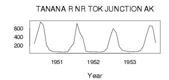
| ID | Year | Jan | Feb | Mar | Apr | May | Jun | Jul | Aug | Sep | Oct | Nov | Dec |
|---|---|---|---|---|---|---|---|---|---|---|---|---|---|
| 7680 | 1950 | 237.66 | 498.08 | 757.87 | 672.40 | 202.99 | 83.51 | 49.04 | 41.91 | ||||
| 7680 | 1951 | 39.62 | 38.31 | 36.79 | 44.43 | 156.21 | 244.14 | 721.93 | 500.91 | 372.99 | 59.06 | 43.86 | 39.62 |
| 7680 | 1952 | 39.62 | 36.79 | 38.26 | 50.94 | 127.29 | 393.93 | 601.37 | 502.04 | 163.57 | 83.54 | 62.26 | 50.94 |
| 7680 | 1953 | 42.45 | 45.28 | 45.28 | 74.99 | 180.15 | 442.61 | 667.31 | 651.46 | 259.73 |
 Return to R-Arctic Net Home Page