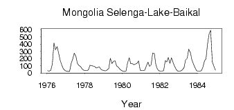
| PointID: | 7673 | Code: | 7200 | Latitude (decimal degrees): | 49.22 | Longitude (decimal degrees): | 102.50 | Drainage Area (km2): | 92300.00 | Source: | SHI | Hydrological Zone: | Yenisei | Name: | Mongolia Selenga-Lake-Baikal |
|---|
| Download | |
|---|---|
| Site Descriptor Information | Site Time Series Data |
| Link to all available data | |
| ID | Year | Jan | Feb | Mar | Apr | May | Jun | Jul | Aug | Sep | Oct | Nov | Dec |
|---|---|---|---|---|---|---|---|---|---|---|---|---|---|
| 7673 | 1976 | 31.00 | 24.50 | 38.50 | 121.00 | 415.00 | 321.00 | 364.00 | 274.00 | 177.00 | 110.00 | 60.00 | 34.00 |
| 7673 | 1977 | 24.50 | 19.50 | 23.50 | 136.00 | 193.00 | 274.00 | 231.00 | 132.00 | 103.00 | 89.50 | 53.50 | 38.50 |
| 7673 | 1978 | 34.00 | 32.50 | 43.00 | 106.00 | 100.00 | 94.50 | 88.00 | 69.00 | 76.50 | 84.00 | 51.00 | 37.50 |
| 7673 | 1979 | 32.50 | 30.00 | 43.00 | 63.00 | 203.00 | 131.00 | 162.00 | 166.00 | 98.00 | 79.50 | 54.50 | 36.50 |
| 7673 | 1980 | 25.50 | 20.50 | 26.00 | 142.00 | 209.00 | 127.00 | 131.00 | 114.00 | 122.00 | 134.00 | 166.00 | 39.00 |
| 7673 | 1981 | 31.00 | 32.50 | 40.50 | 97.50 | 150.00 | 91.50 | 113.00 | 275.00 | 270.00 | 119.00 | 55.50 | 29.50 |
| 7673 | 1982 | 26.50 | 28.00 | 32.50 | 171.00 | 153.00 | 214.00 | 132.00 | 210.00 | 143.00 | 91.00 | 46.50 | 24.50 |
| 7673 | 1983 | 22.00 | 28.50 | 43.50 | 75.50 | 181.00 | 203.00 | 329.00 | 283.00 | 183.00 | 120.00 | 73.50 | 31.00 |
| 7673 | 1984 | 24.50 | 25.50 | 32.50 | 76.50 | 166.00 | 197.00 | 397.00 | 543.00 | 592.00 | 152.00 | 95.50 | 39.00 |
 Return to R-Arctic Net Home Page