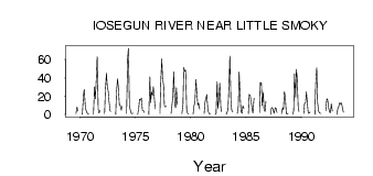
| PointID: | 767 | Code: | 07GG003 | Latitude (decimal degrees): | 54.74 | Longitude (decimal degrees): | -117.15 | Drainage Area (km2): | 1950.00 | Source: | Hydat | Hydrological Zone: | Mackenzie | Name: | IOSEGUN RIVER NEAR LITTLE SMOKY |
|---|
| Download | |
|---|---|
| Site Descriptor Information | Site Time Series Data |
| Link to all available data | |
| ID | Year | Jan | Feb | Mar | Apr | May | Jun | Jul | Aug | Sep | Oct | Nov | Dec |
|---|---|---|---|---|---|---|---|---|---|---|---|---|---|
| 767 | 1969 | 0.97 | 8.19 | 3.70 | |||||||||
| 767 | 1970 | 0.00 | 20.00 | 27.60 | 9.84 | 4.29 | 1.92 | 0.79 | 0.70 | ||||
| 767 | 1971 | 0.00 | 30.00 | 17.00 | 40.40 | 63.20 | 6.11 | 1.56 | 4.01 | ||||
| 767 | 1972 | 1.00 | 26.00 | 45.00 | 31.60 | 25.00 | 13.80 | 3.76 | 3.68 | ||||
| 767 | 1973 | 0.00 | 25.00 | 38.90 | 29.80 | 9.77 | 10.00 | 4.75 | 8.86 | ||||
| 767 | 1974 | 1.00 | 61.00 | 72.30 | 8.27 | 5.18 | 0.85 | 1.17 | 1.23 | ||||
| 767 | 1975 | 0.00 | 7.00 | 16.50 | 15.60 | 17.90 | 4.41 | 4.41 | 2.17 | ||||
| 767 | 1976 | 0.00 | 41.00 | 12.70 | 24.70 | 20.90 | 30.30 | 17.30 | 6.03 | ||||
| 767 | 1977 | 1.00 | 34.00 | 60.60 | 39.60 | 31.30 | 9.21 | 8.14 | 8.99 | ||||
| 767 | 1978 | 1.00 | 9.00 | 19.60 | 46.60 | 11.80 | 7.20 | 29.30 | 10.70 | ||||
| 767 | 1979 | 1.00 | 11.00 | 51.30 | 47.20 | 48.50 | 5.32 | 1.50 | 0.78 | ||||
| 767 | 1980 | 0.00 | 10.00 | 12.90 | 38.30 | 25.30 | 9.98 | 12.40 | 5.78 | ||||
| 767 | 1981 | 1.00 | 13.00 | 18.30 | 21.70 | 4.76 | 2.07 | 0.34 | 0.47 | ||||
| 767 | 1982 | 0.00 | 1.00 | 36.00 | 6.23 | 18.50 | 34.10 | 7.31 | 2.90 | ||||
| 767 | 1983 | 0.00 | 3.00 | 4.71 | 34.40 | 63.70 | 15.00 | 4.72 | 2.62 | ||||
| 767 | 1984 | 1.00 | 9.00 | 46.30 | 19.90 | 3.65 | 1.35 | 9.66 | 6.37 | ||||
| 767 | 1985 | 1.00 | 22.00 | 20.70 | 14.50 | 5.94 | 1.42 | 17.20 | 17.20 | ||||
| 767 | 1986 | 2.00 | 35.00 | 34.40 | 9.69 | 24.20 | 5.01 | 3.35 | 14.30 | ||||
| 767 | 1987 | 0.00 | 7.00 | 7.72 | 4.83 | 1.31 | 7.26 | 7.13 | 2.12 | ||||
| 767 | 1988 | 1.00 | 7.00 | 5.15 | 25.00 | 19.70 | 1.65 | 0.33 | 1.38 | ||||
| 767 | 1989 | 0.00 | 4.00 | 44.50 | 18.80 | 49.30 | 41.00 | 8.41 | 3.20 | ||||
| 767 | 1990 | 1.00 | 12.00 | 13.00 | 24.50 | 11.00 | 1.38 | 1.72 | 2.83 | ||||
| 767 | 1991 | 0.00 | 33.00 | 51.10 | 13.80 | 3.95 | 1.90 | 1.24 | 1.34 | ||||
| 767 | 1992 | 4.00 | 17.00 | 16.40 | 7.19 | 2.61 | 1.73 | 11.50 | 3.89 | ||||
| 767 | 1993 | 0.00 | 7.00 | 8.87 | 13.10 | 11.30 | 12.40 | 7.04 | 2.43 |
 Return to R-Arctic Net Home Page