Malaya Leipy at Sluda
North European Russia
| PointID: | 7655 |
Code: | 71243 |
Latitude (decimal degrees): | 67.57 |
Longitude (decimal degrees): | 30.43 |
Drainage Area (km2): | 23.60 |
Source: | SHI |
Hydrological Zone: | North European Russia |
Name: | Malaya Leipy at Sluda |
Field Definitions
Site Time Series Plot:
Site Data File:
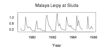
(Units: m3/s)
| ID | Year | Jan | Feb | Mar | Apr | May | Jun | Jul | Aug | Sep | Oct | Nov | Dec |
|---|
| 7655 | 1978 | | | | | | | | | | | 0.28 | 0.17 |
| 7655 | 1979 | 0.13 | 0.13 | 0.15 | 0.16 | 1.04 | 0.58 | 0.34 | 0.30 | 0.37 | 0.34 | 0.25 | 0.17 |
| 7655 | 1980 | 0.13 | 0.11 | 0.12 | 0.10 | 0.48 | 0.77 | 0.23 | 0.25 | 0.23 | 0.26 | 0.18 | 0.14 |
| 7655 | 1981 | 0.12 | 0.11 | 0.11 | 0.08 | 1.00 | 1.15 | 0.78 | 0.52 | 0.37 | 0.36 | 0.20 | 0.15 |
| 7655 | 1982 | 0.13 | 0.11 | 0.12 | 0.13 | 0.85 | 1.28 | 0.53 | 0.42 | 0.59 | 0.33 | 0.24 | 0.19 |
| 7655 | 1983 | 0.18 | 0.17 | 0.15 | 0.18 | 1.04 | 0.69 | 0.43 | 0.45 | 0.37 | 0.47 | 0.31 | 0.27 |
| 7655 | 1984 | 0.22 | 0.20 | 0.17 | 0.13 | 1.12 | 0.42 | 0.80 | 0.58 | 0.32 | 0.27 | 0.20 | 0.21 |
| 7655 | 1985 | | | | | 0.23 | 1.07 | 0.32 | 0.24 | 0.25 | 0.42 | 0.27 | 0.23 |
 Return to R-Arctic Net Home Page