Pulonga at Pulonga
North European Russia
| PointID: | 7633 |
Code: | 71176 |
Latitude (decimal degrees): | 66.26 |
Longitude (decimal degrees): | 39.97 |
Drainage Area (km2): | 670.00 |
Source: | SHI |
Hydrological Zone: | North European Russia |
Name: | Pulonga at Pulonga |
Field Definitions
Site Time Series Plot:
Site Data File:
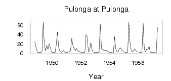
(Units: m3/s)
| ID | Year | Jan | Feb | Mar | Apr | May | Jun | Jul | Aug | Sep | Oct | Nov | Dec |
|---|
| 7633 | 1948 | | | | | | | | | | 25.20 | 11.90 | 2.16 |
| 7633 | 1949 | 1.07 | 1.18 | 1.03 | 2.51 | 66.70 | 17.80 | 4.95 | 16.60 | 7.71 | 19.90 | 12.10 | 2.08 |
| 7633 | 1950 | 1.27 | 1.18 | 0.96 | 16.70 | 45.90 | 13.00 | 3.55 | 1.56 | 2.00 | 5.41 | 2.29 | 1.21 |
| 7633 | 1951 | 1.08 | 2.25 | 2.07 | 5.14 | 31.90 | 15.80 | 10.30 | 5.24 | 10.20 | 5.51 | 3.36 | 2.49 |
| 7633 | 1952 | 1.42 | 0.98 | 1.35 | 1.25 | 39.50 | 35.60 | 3.25 | 4.55 | 22.50 | 7.38 | 2.33 | 1.59 |
| 7633 | 1953 | 1.05 | 1.34 | 1.34 | 1.38 | 63.00 | 9.02 | 7.98 | 5.76 | 5.07 | 5.77 | 4.09 | 2.56 |
| 7633 | 1954 | 1.32 | 0.88 | 0.85 | 0.76 | 35.30 | 9.60 | 2.39 | 2.08 | 9.27 | 11.10 | 5.78 | 4.34 |
| 7633 | 1955 | 2.32 | 1.28 | 1.06 | 1.10 | 66.10 | 22.00 | 5.18 | 2.34 | 4.31 | 8.76 | 5.24 | 2.36 |
| 7633 | 1956 | 2.26 | 1.51 | 1.08 | 0.65 | 65.00 | 8.18 | 3.02 | 8.13 | 6.89 | 14.60 | 2.13 | 1.21 |
| 7633 | 1957 | 1.03 | 0.93 | 0.79 | 0.68 | 54.90 | | | | | | | |
 Return to R-Arctic Net Home Page