Rinda at Rinda
North European Russia
| PointID: | 7621 |
Code: | 71157 |
Latitude (decimal degrees): | 68.90 |
Longitude (decimal degrees): | 36.75 |
Drainage Area (km2): | 980.00 |
Source: | SHI |
Hydrological Zone: | North European Russia |
Name: | Rinda at Rinda |
Field Definitions
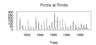
Site Time Series Plot:
Site Data File:
(Units: m3/s)
| ID | Year | Jan | Feb | Mar | Apr | May | Jun | Jul | Aug | Sep | Oct | Nov | Dec |
|---|
| 7621 | 1932 | | | | 2.70 | 8.85 | 202.00 | 75.30 | 16.70 | 20.60 | 24.60 | | |
| 7621 | 1933 | | | | | 5.30 | 73.90 | 12.30 | 5.80 | 4.96 | 7.55 | | |
| 7621 | 1934 | | | | | 59.20 | 53.20 | 39.00 | 7.06 | 5.86 | 5.60 | | |
| 7621 | 1935 | | | | | | 151.00 | 20.30 | 9.16 | 9.06 | 18.80 | 8.05 | |
| 7621 | 1936 | | | | | 66.10 | 17.30 | 5.18 | 4.43 | 12.30 | 15.20 | | |
| 7621 | 1937 | | | | | 46.80 | 24.00 | 6.11 | 4.10 | 6.62 | 16.10 | | |
| 7621 | 1938 | | | | | 14.50 | 214.00 | 29.80 | 7.96 | 5.29 | 5.27 | | |
| 7621 | 1939 | | | | | 5.92 | 137.00 | 14.50 | 5.58 | 11.60 | 15.60 | | |
| 7621 | 1940 | | | | | 55.00 | 79.70 | 24.40 | 14.10 | 21.70 | 17.00 | | |
| 7621 | 1941 | | | | | | 140.00 | 36.10 | 6.11 | 8.00 | 16.10 | | |
| 7621 | 1942 | | | | | | 193.00 | 15.10 | 5.95 | 15.70 | 31.40 | | |
| 7621 | 1943 | | | | | 41.20 | 70.70 | 11.20 | 12.60 | 17.90 | 33.10 | 18.00 | |
| 7621 | 1944 | | | | | 35.60 | 133.00 | 22.80 | 6.30 | 14.80 | 11.40 | 6.55 | |
| 7621 | 1945 | | | | | 34.20 | 297.00 | 16.10 | 2.81 | 11.40 | 24.40 | | |
| 7621 | 1946 | | | | | 19.80 | 223.00 | 18.20 | 8.01 | 6.39 | 6.39 | | |
| 7621 | 1947 | | | | | 157.00 | 164.00 | 14.20 | 6.56 | 6.49 | 5.96 | | |
| 7621 | 1948 | | | | | 192.00 | 144.00 | 9.26 | 4.92 | 15.10 | 29.10 | | |
| 7621 | 1949 | | | | | 113.00 | 58.70 | 23.90 | 10.80 | 12.00 | 31.30 | 20.70 | |
| 7621 | 1950 | | | | | 49.10 | 23.00 | 7.32 | 5.78 | 10.40 | 18.70 | | |
| 7621 | 1951 | | | | | 10.00 | 69.30 | 26.30 | 10.60 | 13.90 | 9.76 | | |
| 7621 | 1952 | | | 2.32 | 3.79 | 138.00 | 137.00 | 13.80 | 13.30 | 13.80 | 10.90 | | |
| 7621 | 1953 | 4.42 | 3.50 | 3.70 | 3.99 | 63.90 | 81.40 | 7.82 | 6.79 | 12.50 | 8.86 | 7.04 | 5.54 |
| 7621 | 1954 | 3.11 | 2.06 | 1.97 | 1.76 | 44.60 | 41.60 | 20.40 | 21.10 | 23.20 | 15.40 | 7.36 | 5.10 |
| 7621 | 1955 | 5.89 | 5.13 | 3.41 | 3.40 | 42.70 | 102.00 | 23.90 | 6.65 | 7.74 | 7.68 | 12.50 | 9.12 |
| 7621 | 1956 | 4.58 | 2.94 | 3.05 | 2.52 | 57.10 | 77.30 | 7.57 | 14.90 | 19.30 | 28.80 | 11.20 | 5.12 |
| 7621 | 1957 | 4.49 | 4.32 | 2.98 | 3.87 | 94.00 | 17.20 | 5.90 | 24.40 | 21.90 | 21.90 | 15.70 | 11.90 |
| 7621 | 1958 | 9.36 | 5.96 | | | | | | | | | | |
 Return to R-Arctic Net Home Page