ROSTA - MOUTH
North European Russia
| PointID: | 7603 |
Code: | 71117 |
Latitude (decimal degrees): | 69.02 |
Longitude (decimal degrees): | 30.80 |
Drainage Area (km2): | 51.70 |
Source: | SHI |
Hydrological Zone: | North European Russia |
Name: | ROSTA - MOUTH |
Field Definitions
Site Time Series Plot:
Site Data File:
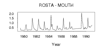
(Units: m3/s)
| ID | Year | Jan | Feb | Mar | Apr | May | Jun | Jul | Aug | Sep | Oct | Nov | Dec |
|---|
| 7603 | 1979 | | | | | | 0.43 | 0.21 | 0.20 | 0.19 | 0.21 | 0.18 | 0.19 |
| 7603 | 1980 | 0.21 | 0.21 | 0.21 | 0.59 | 0.82 | 0.41 | 0.20 | 0.19 | 0.22 | 0.25 | 0.24 | 0.25 |
| 7603 | 1981 | 0.25 | 0.21 | 0.24 | 0.28 | 1.52 | 1.00 | 0.55 | 0.43 | 0.31 | 0.32 | 0.23 | 0.21 |
| 7603 | 1982 | 0.18 | 0.19 | 0.18 | 0.57 | 1.44 | 0.83 | 0.63 | 0.37 | 0.45 | 0.32 | 0.32 | 0.26 |
| 7603 | 1983 | 0.25 | 0.28 | 0.23 | 1.16 | 0.61 | 0.37 | 0.25 | 0.36 | 0.32 | 0.42 | 0.25 | 0.24 |
| 7603 | 1984 | 0.24 | 0.22 | 0.22 | 0.47 | 1.85 | 0.57 | 0.86 | 0.32 | 0.29 | 0.30 | 0.27 | 0.23 |
| 7603 | 1985 | 0.21 | 0.16 | 0.22 | 0.32 | 0.68 | 0.40 | 0.29 | 0.27 | 0.40 | 0.42 | 0.37 | 0.27 |
| 7603 | 1986 | 0.24 | 0.21 | 0.27 | 0.63 | 1.54 | 0.47 | 0.35 | 0.34 | 0.34 | 0.53 | 0.31 | 0.30 |
| 7603 | 1987 | 0.33 | 0.34 | 0.35 | 0.45 | 1.12 | 0.36 | 0.42 | 0.48 | 0.60 | 0.33 | 0.31 | 0.34 |
| 7603 | 1989 | 0.40 | 0.36 | 0.38 | 2.08 | 1.17 | 1.02 | 0.51 | 0.31 | 0.45 | 0.34 | 0.53 | 0.39 |
| 7603 | 1990 | 0.34 | 0.43 | 0.43 | 1.55 | 0.74 | 0.53 | 0.62 | 0.50 | 0.55 | 0.63 | 0.70 | 0.74 |
 Return to R-Arctic Net Home Page