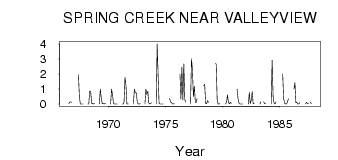
| PointID: | 758 | Code: | 07GF002 | Latitude (decimal degrees): | 54.91 | Longitude (decimal degrees): | -117.84 | Drainage Area (km2): | 112.00 | Source: | Hydat | Hydrological Zone: | Mackenzie | Name: | SPRING CREEK NEAR VALLEYVIEW |
|---|
| Download | |
|---|---|
| Site Descriptor Information | Site Time Series Data |
| Link to all available data | |
| ID | Year | Jan | Feb | Mar | Apr | May | Jun | Jul | Aug | Sep | Oct | Nov | Dec |
|---|---|---|---|---|---|---|---|---|---|---|---|---|---|
| 758 | 1966 | 0.03 | 0.13 | 0.14 | 0.12 | ||||||||
| 758 | 1967 | 1.97 | 0.45 | 0.01 | 2.0e-03 | 0.00 | 0.00 | ||||||
| 758 | 1968 | 0.00 | 0.00 | 0.87 | 0.84 | 0.03 | 0.06 | 0.01 | 0.03 | ||||
| 758 | 1969 | 0.00 | 1.00 | 0.41 | 0.02 | 0.05 | 2.0e-03 | 0.03 | 0.03 | ||||
| 758 | 1970 | 0.00 | 1.00 | 0.61 | 0.05 | 3.0e-03 | 0.00 | 0.00 | 0.00 | ||||
| 758 | 1971 | 0.00 | 0.00 | 0.14 | 1.78 | 1.25 | 5.0e-03 | 6.0e-03 | 0.01 | ||||
| 758 | 1972 | 0.00 | 1.00 | 0.75 | 0.75 | 0.16 | 0.01 | 7.0e-03 | 0.02 | ||||
| 758 | 1973 | 0.00 | 1.00 | 0.64 | 0.85 | 0.08 | 0.01 | 0.04 | 0.09 | ||||
| 758 | 1974 | 0.00 | 4.00 | 1.91 | 0.06 | 4.0e-03 | 1.0e-03 | 2.0e-03 | 7.0e-03 | ||||
| 758 | 1975 | 0.37 | 0.14 | 0.10 | 6.0e-03 | 0.01 | 0.03 | ||||||
| 758 | 1976 | 2.00 | 0.34 | 2.45 | 0.27 | 2.67 | 0.29 | 0.13 | |||||
| 758 | 1977 | 0.00 | 3.00 | 2.26 | 0.50 | 1.18 | 0.14 | 0.08 | 0.36 | ||||
| 758 | 1978 | 1.22 | 1.32 | 0.05 | 0.02 | 0.23 | 0.12 | ||||||
| 758 | 1979 | 2.69 | 2.65 | 0.31 | 7.0e-03 | 0.02 | 9.0e-03 | ||||||
| 758 | 1980 | 0.00 | 0.14 | 0.61 | 0.12 | 0.02 | 0.12 | 0.04 | |||||
| 758 | 1981 | 1.00 | 0.36 | 0.06 | 0.01 | 1.0e-03 | 0.00 | 0.00 | |||||
| 758 | 1982 | 0.00 | 0.77 | 0.04 | 0.25 | 0.83 | 0.04 | 0.02 | |||||
| 758 | 1983 | 0.00 | 0.15 | 0.15 | 0.02 | 0.02 | |||||||
| 758 | 1984 | 0.00 | 2.91 | 0.53 | 0.05 | 0.01 | 0.14 | ||||||
| 758 | 1985 | 2.00 | 0.37 | 0.06 | 6.0e-03 | 0.01 | 0.15 | 0.35 | |||||
| 758 | 1986 | 1.00 | 1.43 | 0.09 | 0.11 | 0.01 | 0.01 | 0.10 | |||||
| 758 | 1987 | 0.00 | 0.11 | 0.06 | 0.02 | 0.13 | 0.02 |
 Return to R-Arctic Net Home Page