NAMA-JOKI - LUOSTARI
North European Russia
| PointID: | 7574 |
Code: | 71024 |
Latitude (decimal degrees): | 69.58 |
Longitude (decimal degrees): | 37.00 |
Drainage Area (km2): | 142.00 |
Source: | SHI |
Hydrological Zone: | North European Russia |
Name: | NAMA-JOKI - LUOSTARI |
Field Definitions
Site Time Series Plot:
Site Data File:
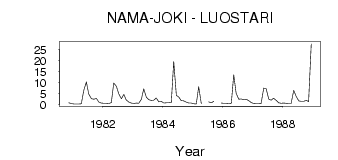
(Units: m3/s)
| ID | Year | Jan | Feb | Mar | Apr | May | Jun | Jul | Aug | Sep | Oct | Nov | Dec |
|---|
| 7574 | 1980 | | | | | | | | | | | 0.78 | 0.51 |
| 7574 | 1981 | 0.29 | 0.22 | 0.25 | 0.33 | 6.35 | 10.30 | 4.76 | 2.64 | 2.40 | 2.80 | 1.14 | 0.66 |
| 7574 | 1982 | 0.57 | 0.53 | 0.46 | 0.89 | 9.75 | 8.38 | 4.86 | 2.62 | 4.62 | 2.13 | 1.12 | 0.64 |
| 7574 | 1983 | 0.46 | 0.73 | 0.57 | 2.31 | 7.17 | 3.30 | 2.21 | 1.85 | 1.95 | 3.00 | 1.22 | 1.48 |
| 7574 | 1984 | 0.67 | 0.78 | 0.85 | 1.01 | 19.60 | 4.20 | 3.46 | 1.75 | 1.70 | 1.18 | 0.65 | 0.71 |
| 7574 | 1985 | 0.40 | 0.30 | 8.13 | 0.39 | | | 1.24 | 0.77 | 1.47 | | | 0.71 |
| 7574 | 1986 | 0.59 | 0.57 | 0.51 | 0.60 | 13.60 | 5.15 | 2.42 | 2.51 | 2.22 | 2.40 | 1.82 | 0.94 |
| 7574 | 1987 | 0.47 | 0.37 | 0.41 | 0.44 | 7.51 | 7.26 | 2.45 | 2.05 | 2.87 | 1.86 | 0.79 | 0.53 |
| 7574 | 1988 | 0.66 | 0.59 | 0.49 | 0.49 | 6.48 | 3.72 | 1.66 | 1.41 | 1.42 | 1.89 | 1.36 | 27.60 |
 Return to R-Arctic Net Home Page