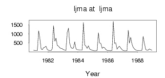
Ijma at Ijma
North European Russia
| PointID: | 7512 |
Code: | 70514 |
Latitude (decimal degrees): | 65.02 |
Longitude (decimal degrees): | 53.90 |
Drainage Area (km2): | 28700.00 |
Source: | SHI |
Hydrological Zone: | North European Russia |
Name: | Ijma at Ijma |
Field Definitions
Site Time Series Plot:

Site Data File:
(Units: m3/s)
| ID | Year | Jan | Feb | Mar | Apr | May | Jun | Jul | Aug | Sep | Oct | Nov | Dec |
|---|
| 7512 | 1981 | 91.50 | 84.80 | 72.70 | 73.60 | 1170.00 | 773.00 | 170.00 | 124.00 | 228.00 | 265.00 | 313.00 | 127.00 |
| 7512 | 1982 | 93.40 | 76.50 | 73.10 | 172.00 | 1450.00 | 591.00 | 762.00 | 359.00 | 322.00 | 233.00 | 200.00 | 179.00 |
| 7512 | 1983 | 123.00 | 100.00 | 87.40 | 1080.00 | 1320.00 | 487.00 | 245.00 | 199.00 | 210.00 | 560.00 | 187.00 | 120.00 |
| 7512 | 1984 | 118.00 | 98.60 | 97.60 | 104.00 | 1620.00 | 387.00 | 327.00 | 195.00 | 338.00 | 164.00 | 120.00 | 97.20 |
| 7512 | 1985 | 75.70 | 65.80 | 69.70 | 80.40 | 1060.00 | 498.00 | 467.00 | 199.00 | 265.00 | 227.00 | 138.00 | 85.80 |
| 7512 | 1986 | 78.80 | 72.10 | 67.00 | 93.70 | 1690.00 | 476.00 | 510.00 | 152.00 | 265.00 | 312.00 | 209.00 | 129.00 |
| 7512 | 1987 | 81.90 | 69.70 | 69.20 | 74.10 | 1200.00 | 491.00 | 800.00 | 430.00 | 256.00 | 166.00 | 106.00 | 86.30 |
| 7512 | 1988 | 79.40 | 72.40 | 72.80 | 103.00 | 858.00 | 472.00 | 131.00 | 91.40 | 101.00 | 162.00 | 129.00 | 92.80 |
 Return to R-Arctic Net Home Page


 Return to R-Arctic Net Home Page