Kolva at Kolva
North European Russia
| PointID: | 7507 |
Code: | 70501 |
Latitude (decimal degrees): | 66.33 |
Longitude (decimal degrees): | 56.46 |
Drainage Area (km2): | 15000.00 |
Source: | SHI |
Hydrological Zone: | North European Russia |
Name: | Kolva at Kolva |
Field Definitions
Site Time Series Plot:
Site Data File:
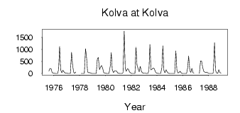
(Units: m3/s)
| ID | Year | Jan | Feb | Mar | Apr | May | Jun | Jul | Aug | Sep | Oct | Nov | Dec |
|---|
| 7507 | 1975 | | | | | | | | 104.00 | 203.00 | 202.00 | 38.50 | 15.20 |
| 7507 | 1976 | 6.11 | 2.79 | 2.07 | 3.22 | 164.00 | 1120.00 | 151.00 | 28.80 | 136.00 | 76.00 | 21.90 | 12.90 |
| 7507 | 1977 | 6.02 | 2.54 | 1.38 | 4.28 | 881.00 | 359.00 | 61.50 | 10.90 | 58.00 | | | |
| 7507 | 1978 | | 4.20 | 2.32 | 2.00 | 3.10 | 1030.00 | 667.00 | 75.00 | 30.80 | 34.70 | 14.70 | 2.97 |
| 7507 | 1979 | 0.45 | 0.17 | 0.07 | 0.09 | 583.00 | 670.00 | 162.00 | 268.00 | 330.00 | 203.00 | 36.90 | 16.60 |
| 7507 | 1980 | 8.20 | 2.79 | 2.18 | 7.29 | 306.00 | 864.00 | 153.00 | 39.60 | 111.00 | 115.00 | 96.30 | 20.70 |
| 7507 | 1981 | 7.94 | 3.74 | 2.42 | 1.89 | 36.00 | 1760.00 | 201.00 | 95.20 | 202.00 | 173.00 | 62.00 | 26.50 |
| 7507 | 1982 | 5.38 | 2.97 | 2.04 | 5.30 | 1090.00 | 352.00 | 186.00 | 74.00 | 297.00 | 90.00 | 28.80 | 16.80 |
| 7507 | 1983 | 9.59 | 6.55 | 3.37 | 3.70 | 130.00 | 1200.00 | 152.00 | 187.00 | 228.00 | 208.00 | 75.80 | 19.80 |
| 7507 | 1984 | 7.05 | 3.64 | 2.62 | 1.96 | 244.00 | 1150.00 | 131.00 | 31.50 | 160.00 | 67.10 | 14.40 | 4.96 |
| 7507 | 1985 | 4.43 | 3.12 | 1.96 | 1.38 | 3.94 | 936.00 | 160.00 | 24.60 | 34.70 | 91.20 | 31.70 | 5.52 |
| 7507 | 1986 | 2.33 | 1.21 | 1.62 | 1.78 | 228.00 | 727.00 | 123.00 | 46.80 | 212.00 | 27.00 | 23.80 | |
| 7507 | 1987 | | | | 0.94 | 519.00 | 513.00 | 264.00 | 90.00 | 58.50 | 39.50 | 59.50 | 19.10 |
| 7507 | 1988 | 3.30 | 1.31 | 0.81 | 1.32 | 29.80 | 1270.00 | 126.00 | 26.80 | 12.20 | 160.00 | 44.00 | 13.90 |
 Return to R-Arctic Net Home Page