Adzva at Salyukuvom
North European Russia
| PointID: | 7503 |
Code: | 70495 |
Latitude (decimal degrees): | 66.70 |
Longitude (decimal degrees): | 59.20 |
Drainage Area (km2): | 14700.00 |
Source: | SHI |
Hydrological Zone: | North European Russia |
Name: | Adzva at Salyukuvom |
Field Definitions
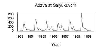
Site Time Series Plot:
Site Data File:
(Units: m3/s)
| ID | Year | Jan | Feb | Mar | Apr | May | Jun | Jul | Aug | Sep | Oct | Nov | Dec |
|---|
| 7503 | 1953 | 3.27 | 2.73 | 2.52 | 27.40 | 405.00 | 189.00 | 110.00 | 32.90 | 78.50 | 61.20 | 12.80 | 6.21 |
| 7503 | 1954 | 5.22 | 3.66 | 3.35 | 15.10 | 535.00 | 451.00 | 154.00 | 28.60 | 90.30 | 80.50 | 25.60 | 10.40 |
| 7503 | 1955 | 7.46 | 4.76 | 3.98 | 76.40 | 474.00 | 157.00 | 63.20 | 49.10 | 118.00 | 193.00 | 51.90 | 15.40 |
| 7503 | 1956 | 7.64 | 5.38 | 3.89 | 3.96 | 424.00 | 232.00 | 102.00 | 48.40 | 259.00 | 201.00 | 21.20 | 8.73 |
| 7503 | 1957 | 6.76 | 4.96 | 4.10 | 3.78 | 476.00 | 438.00 | 151.00 | 40.30 | 216.00 | 93.60 | 23.30 | 8.44 |
| 7503 | 1958 | 6.07 | 4.82 | 4.91 | 4.90 | 8.43 | 851.00 | 176.00 | 133.00 | 101.00 | 110.00 | 47.50 | 8.21 |
| 7503 | 1959 | 5.32 | 4.48 | 4.02 | 4.41 | | | | | | | | |
| Other Close Sites |
|---|
| PointID |
Latitude |
Longitude | Drainage Area | Source |
Name |
|---|
| 7498 | 66.55 | 59.42 | 54700.00 | SHI | Usa at Adzva |
 Return to R-Arctic Net Home Page