Ilich at Priuralsk
North European Russia
| PointID: | 7487 |
Code: | 70444 |
Latitude (decimal degrees): | 62.63 |
Longitude (decimal degrees): | 57.47 |
Drainage Area (km2): | 10500.00 |
Source: | SHI |
Hydrological Zone: | North European Russia |
Name: | Ilich at Priuralsk |
Field Definitions
Site Time Series Plot:
Site Data File:
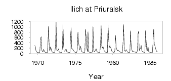
(Units: m3/s)
| ID | Year | Jan | Feb | Mar | Apr | May | Jun | Jul | Aug | Sep | Oct | Nov | Dec |
|---|
| 7487 | 1969 | | | | | | | | 298.00 | 237.00 | 83.10 | 53.00 | 43.90 |
| 7487 | 1970 | 35.60 | 33.80 | 33.00 | 42.90 | 539.00 | 633.00 | 134.00 | 76.90 | 63.60 | 153.00 | 103.00 | 54.80 |
| 7487 | 1971 | 38.20 | 34.80 | 31.00 | 35.80 | 398.00 | 1030.00 | 192.00 | 94.60 | 244.00 | 184.00 | 82.80 | 57.70 |
| 7487 | 1972 | 39.30 | 32.30 | 28.20 | 37.50 | 296.00 | 1180.00 | 143.00 | 103.00 | 128.00 | 176.00 | 51.60 | 44.90 |
| 7487 | 1973 | 39.90 | 36.50 | 31.90 | 193.00 | 1090.00 | 306.00 | 82.50 | 87.90 | 136.00 | 166.00 | 63.70 | 59.20 |
| 7487 | 1974 | 45.00 | 35.80 | 34.40 | 37.10 | 655.00 | 971.00 | 173.00 | 178.00 | 145.00 | 112.00 | 62.70 | 48.20 |
| 7487 | 1975 | 39.20 | 34.30 | 32.90 | 183.00 | 804.00 | 406.00 | 217.00 | 128.00 | 271.00 | 180.00 | 64.80 | 58.00 |
| 7487 | 1976 | 45.10 | 42.30 | 35.20 | 45.60 | 910.00 | 671.00 | 229.00 | 60.40 | 822.00 | 66.50 | 47.50 | 43.20 |
| 7487 | 1977 | 36.70 | 30.70 | 28.00 | 62.60 | 1010.00 | 165.00 | 58.80 | 78.90 | 139.00 | 172.00 | 89.60 | 58.50 |
| 7487 | 1978 | 40.90 | 37.30 | 33.20 | 54.00 | 348.00 | 1050.00 | 285.00 | 202.00 | 267.00 | 170.00 | 93.00 | 70.20 |
| 7487 | 1979 | 48.30 | 40.00 | 35.30 | 38.20 | 1080.00 | 557.00 | 223.00 | 297.00 | 217.00 | 197.00 | 83.00 | 58.80 |
| 7487 | 1980 | 48.10 | 40.20 | 37.20 | 100.00 | 680.00 | 237.00 | 150.00 | 104.00 | 125.00 | 105.00 | 76.60 | 58.10 |
| 7487 | 1981 | 47.50 | 39.90 | 36.80 | 32.50 | 362.00 | 1090.00 | 134.00 | 87.90 | 79.10 | 145.00 | 109.00 | 61.50 |
| 7487 | 1982 | 40.70 | 35.40 | 31.30 | 53.10 | 857.00 | 331.00 | 154.00 | 70.00 | 75.50 | 67.40 | 62.80 | 52.40 |
| 7487 | 1983 | 46.00 | 38.60 | 34.20 | 118.00 | 742.00 | 840.00 | 107.00 | 164.00 | 179.00 | 301.00 | 104.00 | 76.50 |
| 7487 | 1984 | 58.90 | 49.50 | 42.30 | 39.80 | 861.00 | 462.00 | 127.00 | 95.30 | 284.00 | 79.50 | 50.00 | 46.00 |
| 7487 | 1985 | 38.10 | 35.30 | 34.90 | 34.00 | 445.00 | 910.00 | 346.00 | 292.00 | 197.00 | 123.00 | 73.80 | 58.00 |
 Return to R-Arctic Net Home Page