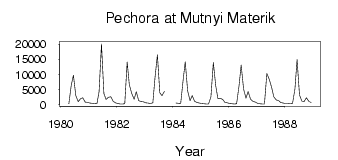
| PointID: | 7484 | Code: | 70429 | Latitude (decimal degrees): | 65.95 | Longitude (decimal degrees): | 55.17 | Drainage Area (km2): | 205000.00 | Source: | SHI | Hydrological Zone: | North European Russia | Name: | Pechora at Mutnyi Materik |
|---|
| Download | |
|---|---|
| Site Descriptor Information | Site Time Series Data |
| Link to all available data | |
| ID | Year | Jan | Feb | Mar | Apr | May | Jun | Jul | Aug | Sep | Oct | Nov | Dec |
|---|---|---|---|---|---|---|---|---|---|---|---|---|---|
| 7484 | 1980 | 361.00 | 6440.00 | 9800.00 | 3070.00 | 1050.00 | 2020.00 | 2330.00 | 865.00 | 841.00 | |||
| 7484 | 1981 | 610.00 | 469.00 | 399.00 | 342.00 | 4400.00 | 20100.00 | 3780.00 | 1770.00 | 2520.00 | 2660.00 | 1210.00 | 648.00 |
| 7484 | 1982 | 418.00 | 298.00 | 243.00 | 327.00 | 14100.00 | 6600.00 | 3790.00 | 1840.00 | 4310.00 | 1370.00 | 1030.00 | 1020.00 |
| 7484 | 1983 | 703.00 | 567.00 | 441.00 | 694.00 | 9000.00 | 16500.00 | 4030.00 | 3040.00 | 4380.00 | |||
| 7484 | 1984 | 587.00 | 469.00 | 423.00 | 8010.00 | 14200.00 | 4520.00 | 1370.00 | 3010.00 | 1100.00 | 708.00 | 567.00 | |
| 7484 | 1985 | 404.00 | 326.00 | 298.00 | 295.00 | 2650.00 | 14000.00 | 6280.00 | 2090.00 | 2160.00 | 1760.00 | 832.00 | 625.00 |
| 7484 | 1986 | 449.00 | 361.00 | 294.00 | 320.00 | 6210.00 | 13100.00 | 5260.00 | 2200.00 | 4390.00 | 1880.00 | 1150.00 | 916.00 |
| 7484 | 1987 | 499.00 | 365.00 | 277.00 | 251.00 | 10300.00 | 8450.00 | 5740.00 | 2650.00 | 1610.00 | 1400.00 | 704.00 | 550.00 |
| 7484 | 1988 | 465.00 | 392.00 | 359.00 | 438.00 | 5190.00 | 14900.00 | 3260.00 | 1240.00 | 1050.00 | 2290.00 | 1100.00 | 716.00 |
 Return to R-Arctic Net Home Page