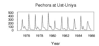
Pechora at Ust-Uniya
North European Russia
| PointID: | 7480 |
Code: | 70408 |
Latitude (decimal degrees): | 61.80 |
Longitude (decimal degrees): | 57.92 |
Drainage Area (km2): | 4430.00 |
Source: | SHI |
Hydrological Zone: | North European Russia |
Name: | Pechora at Ust-Uniya |
Field Definitions
Site Time Series Plot:
Site Data File:
(Units: m3/s)
| ID | Year | Jan | Feb | Mar | Apr | May | Jun | Jul | Aug | Sep | Oct | Nov | Dec |
|---|
| 7480 | 1975 | 14.20 | 12.70 | 11.80 | 124.00 | 310.00 | 108.00 | 73.50 | 55.40 | 111.00 | 91.80 | 34.50 | 26.10 |
| 7480 | 1976 | 19.30 | 14.30 | 13.60 | 19.60 | 467.00 | 208.00 | 47.30 | 21.30 | 27.50 | 22.40 | 16.40 | 16.60 |
| 7480 | 1977 | 14.00 | 13.10 | 12.40 | 54.20 | 448.00 | 63.40 | 23.30 | 51.50 | 96.10 | 73.90 | 46.70 | 26.20 |
| 7480 | 1978 | 15.80 | 12.90 | 11.90 | 21.70 | 189.00 | 431.00 | 86.90 | 83.20 | 81.80 | 74.90 | 35.80 | 21.40 |
| 7480 | 1979 | 13.90 | 13.60 | 12.70 | 11.80 | 498.00 | 218.00 | 98.80 | 123.00 | 83.10 | 108.00 | 36.70 | 23.90 |
| 7480 | 1980 | 19.30 | 15.20 | 14.00 | 32.60 | 272.00 | 78.70 | 50.30 | 50.80 | 50.20 | 32.30 | 32.50 | 18.60 |
| 7480 | 1981 | 16.70 | 15.20 | 12.20 | 10.40 | 177.00 | 388.00 | 43.50 | 27.00 | 30.70 | 49.20 | 50.40 | 24.10 |
| 7480 | 1982 | 10.30 | 8.63 | 10.70 | 24.40 | 376.00 | 129.00 | 54.40 | 27.20 | 19.00 | 18.40 | 19.60 | 17.60 |
| 7480 | 1983 | 14.10 | 11.30 | 9.67 | 103.00 | 325.00 | 221.00 | 34.60 | 47.10 | 63.80 | | | |
| 7480 | 1984 | | | 14.40 | 14.90 | 407.00 | 133.00 | 55.90 | 27.50 | 116.00 | 42.50 | 21.00 | 16.20 |
| 7480 | 1985 | 12.60 | 10.60 | 10.40 | 11.60 | 238.00 | 252.00 | 160.00 | 122.00 | 66.80 | 49.50 | 23.90 | 15.50 |
 Return to R-Arctic Net Home Page