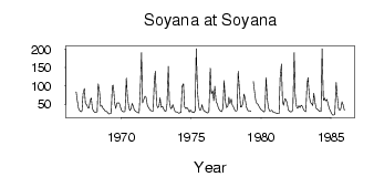
Soyana at Soyana
North European Russia
| PointID: | 7464 |
Code: | 70374 |
Latitude (decimal degrees): | 65.78 |
Longitude (decimal degrees): | 43.37 |
Drainage Area (km2): | 5570.00 |
Source: | SHI |
Hydrological Zone: | North European Russia |
Name: | Soyana at Soyana |
Field Definitions
Site Time Series Plot:
Site Data File:
(Units: m3/s)
| ID | Year | Jan | Feb | Mar | Apr | May | Jun | Jul | Aug | Sep | Oct | Nov | Dec |
|---|
| 7464 | 1966 | | | | | | | | | | 83.50 | 61.30 | 39.00 |
| 7464 | 1967 | 32.60 | 29.00 | 32.40 | 79.20 | 93.10 | 51.70 | 49.00 | 40.70 | 39.50 | 62.00 | 67.10 | 38.30 |
| 7464 | 1968 | 30.90 | 28.00 | 28.90 | 29.50 | 106.00 | 83.00 | 44.50 | 45.70 | 38.40 | 36.00 | 31.00 | 30.50 |
| 7464 | 1969 | 27.30 | 23.30 | 24.40 | 26.00 | 101.00 | 102.00 | 53.00 | 38.70 | 53.70 | 53.00 | 54.00 | 41.70 |
| 7464 | 1970 | 32.80 | 30.30 | 29.00 | 30.50 | 121.00 | 71.40 | 42.90 | 33.20 | 37.20 | 52.30 | 44.30 | 33.80 |
| 7464 | 1971 | 31.30 | 28.70 | 27.00 | 26.60 | 83.40 | 191.00 | 53.70 | 64.10 | 71.80 | 69.80 | 47.70 | 41.70 |
| 7464 | 1972 | 36.20 | 32.70 | 31.20 | 31.70 | 114.00 | 140.00 | 48.70 | 40.20 | 45.30 | 67.70 | 41.90 | 44.40 |
| 7464 | 1973 | 37.00 | 31.70 | 30.70 | 49.50 | 153.00 | 58.40 | 37.70 | 41.00 | 49.20 | 36.80 | 29.40 | 29.30 |
| 7464 | 1974 | 28.10 | 25.50 | 27.50 | 28.00 | 98.70 | 106.00 | 43.00 | 37.90 | 41.00 | 37.20 | 28.80 | 34.40 |
| 7464 | 1975 | 29.90 | 27.80 | 27.50 | 32.40 | 202.00 | 84.50 | 46.50 | 34.50 | 35.20 | 49.10 | 35.90 | 31.60 |
| 7464 | 1976 | 29.10 | 26.90 | 26.20 | 31.40 | 149.00 | 77.90 | 86.70 | 59.90 | 98.80 | 56.90 | 51.60 | 38.70 |
| 7464 | 1977 | 34.20 | 30.60 | 30.40 | 43.30 | 115.00 | 56.70 | 40.60 | 44.60 | 69.50 | 51.80 | 63.90 | 47.60 |
| 7464 | 1978 | 41.30 | 34.10 | 31.80 | 33.30 | 140.00 | 88.60 | 42.60 | 43.10 | 52.60 | 78.10 | 66.10 | 42.80 |
| 7464 | 1979 | 34.10 | 31.20 | 32.10 | 30.70 | | 113.00 | 82.70 | 61.50 | 52.50 | 49.80 | 43.70 | 37.20 |
| 7464 | 1980 | 34.50 | 32.20 | 29.60 | 33.30 | 123.00 | 62.80 | 39.80 | 31.30 | 32.10 | 33.90 | 28.60 | 28.00 |
| 7464 | 1981 | 26.10 | 25.80 | 24.20 | 24.70 | 122.00 | 160.00 | 57.20 | 47.10 | 65.00 | 62.30 | 53.70 | 34.60 |
| 7464 | 1982 | 30.60 | 29.30 | 29.40 | 35.90 | 191.00 | 72.70 | 42.70 | 38.60 | 46.00 | 40.70 | 47.60 | 44.70 |
| 7464 | 1983 | 36.20 | 32.20 | 30.30 | 103.00 | 123.00 | 71.00 | 55.50 | 51.20 | 46.80 | 79.80 | 52.60 | 38.70 |
| 7464 | 1984 | 36.00 | 33.20 | 30.20 | 30.60 | 202.00 | 60.20 | 67.20 | 59.00 | 63.50 | 52.90 | 37.90 | 33.10 |
| 7464 | 1985 | 25.70 | 20.80 | 20.40 | 23.00 | 110.00 | 74.10 | 38.30 | 33.70 | 36.50 | 56.60 | 48.60 | 33.50 |
 Return to R-Arctic Net Home Page