| PointID: | 745 | Code: | 07GB002 | Latitude (decimal degrees): | 54.37 | Longitude (decimal degrees): | -118.59 | Drainage Area (km2): | 3300.00 | Source: | Hydat | Hydrological Zone: | Mackenzie | Name: | KAKWA RIVER NEAR GRANDE PRAIRIE |
|---|
| Download | |
|---|---|
| Site Descriptor Information | Site Time Series Data |
| Link to all available data | |
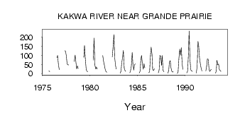
| ID | Year | Jan | Feb | Mar | Apr | May | Jun | Jul | Aug | Sep | Oct | Nov | Dec |
|---|---|---|---|---|---|---|---|---|---|---|---|---|---|
| 745 | 1975 | 15.10 | 11.20 | ||||||||||
| 745 | 1976 | 87.40 | 99.70 | 50.90 | 21.60 | ||||||||
| 745 | 1977 | 126.00 | 122.00 | 99.60 | 52.90 | 48.40 | 47.80 | ||||||
| 745 | 1978 | 66.90 | 102.00 | 68.00 | 26.40 | 43.50 | 28.20 | ||||||
| 745 | 1979 | 89.60 | 155.00 | 79.10 | 22.80 | 13.30 | 11.70 | ||||||
| 745 | 1980 | 74.00 | 196.00 | 46.50 | 25.90 | 36.90 | 25.80 | ||||||
| 745 | 1981 | 100.00 | 67.10 | 44.80 | 25.60 | 11.20 | 8.05 | ||||||
| 745 | 1982 | 92.60 | 150.00 | 215.00 | 89.90 | 46.30 | 25.50 | ||||||
| 745 | 1983 | 3.00 | 14.00 | 62.20 | 93.20 | 128.00 | 31.30 | 16.50 | 12.90 | ||||
| 745 | 1984 | 5.00 | 15.00 | 43.00 | 117.00 | 53.90 | 20.10 | 47.80 | 53.90 | ||||
| 745 | 1985 | 4.00 | 12.00 | 82.70 | 100.00 | 49.60 | 24.40 | 55.30 | 32.10 | ||||
| 745 | 1986 | 5.00 | 11.00 | 98.60 | 145.00 | 108.00 | 21.80 | 17.10 | 27.30 | ||||
| 745 | 1987 | 4.00 | 21.00 | 99.50 | 97.20 | 44.40 | 99.50 | 18.10 | 10.30 | ||||
| 745 | 1988 | 3.00 | 16.00 | 61.80 | 71.50 | 34.90 | 14.60 | 8.57 | 10.20 | ||||
| 745 | 1989 | 1.00 | 9.00 | 84.90 | 134.00 | 102.00 | 143.00 | 55.50 | 23.30 | ||||
| 745 | 1990 | 4.00 | 14.00 | 110.00 | 234.00 | 74.70 | 20.30 | 15.80 | 12.10 | ||||
| 745 | 1991 | 3.00 | 41.00 | 177.00 | 153.00 | 85.60 | 52.60 | 32.20 | 14.40 | ||||
| 745 | 1992 | 15.00 | 43.00 | 81.00 | 78.60 | 23.10 | 12.20 | 19.70 | 23.90 | ||||
| 745 | 1993 | 3.00 | 12.00 | 74.20 | 49.10 | 52.60 | 24.90 | 17.40 | 12.40 |
 Return to R-Arctic Net Home Page