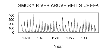
| PointID: | 742 | Code: | 07GA001 | Latitude (decimal degrees): | 53.94 | Longitude (decimal degrees): | -119.16 | Drainage Area (km2): | 3840.00 | Source: | Hydat | Hydrological Zone: | Mackenzie | Name: | SMOKY RIVER ABOVE HELLS CREEK |
|---|
| Download | |
|---|---|
| Site Descriptor Information | Site Time Series Data |
| Link to all available data | |
| ID | Year | Jan | Feb | Mar | Apr | May | Jun | Jul | Aug | Sep | Oct | Nov | Dec |
|---|---|---|---|---|---|---|---|---|---|---|---|---|---|
| 742 | 1968 | 134.00 | 177.00 | 160.00 | 160.00 | 112.00 | 49.60 | 33.00 | 16.00 | ||||
| 742 | 1969 | 14.00 | 13.00 | 14.00 | 30.00 | 128.00 | 250.00 | 152.00 | 190.00 | 98.70 | 62.40 | 33.00 | 11.00 |
| 742 | 1970 | 11.00 | 13.00 | 11.00 | 15.00 | 74.10 | 303.00 | 166.00 | 107.00 | 50.50 | 37.00 | 16.00 | 11.00 |
| 742 | 1971 | 10.00 | 15.00 | 12.00 | 18.00 | 149.00 | 306.00 | 246.00 | 148.00 | 84.00 | 65.30 | 31.00 | 21.00 |
| 742 | 1972 | 13.00 | 11.00 | 12.00 | 14.00 | 168.00 | 442.00 | 195.00 | 148.00 | 26.00 | 18.00 | ||
| 742 | 1973 | 14.00 | 11.00 | 11.00 | 13.00 | 128.00 | 244.00 | 170.00 | 110.00 | 70.20 | 62.50 | 22.00 | 21.00 |
| 742 | 1974 | 14.00 | 11.00 | 11.00 | 17.00 | 82.20 | 308.00 | 224.00 | 129.00 | 80.70 | 69.60 | 27.00 | 21.00 |
| 742 | 1975 | 15.00 | 10.00 | 10.00 | 12.00 | 64.40 | 195.00 | 259.00 | 102.00 | 66.40 | 39.70 | 37.00 | 19.00 |
| 742 | 1976 | 12.00 | 13.00 | 12.00 | 28.00 | 140.00 | 184.00 | 228.00 | 199.00 | 115.00 | 52.00 | 25.00 | 21.00 |
| 742 | 1977 | 15.00 | 13.00 | 10.00 | 27.00 | 112.00 | 259.00 | 231.00 | 158.00 | 74.30 | 42.30 | 22.00 | 19.00 |
| 742 | 1978 | 13.00 | 10.00 | 11.00 | 19.00 | 72.60 | 222.00 | 213.00 | 107.00 | 91.90 | 67.90 | 35.00 | 21.00 |
| 742 | 1979 | 14.00 | 11.00 | 12.00 | 13.00 | 79.20 | 268.00 | 239.00 | 121.00 | 67.30 | 37.70 | 14.00 | 10.00 |
| 742 | 1980 | 10.00 | 9.00 | 9.00 | 34.00 | 136.00 | 257.00 | 153.00 | 114.00 | 85.60 | 60.80 | 26.00 | 31.00 |
| 742 | 1981 | 24.00 | 12.00 | 13.00 | 19.00 | 168.00 | 157.00 | 191.00 | 139.00 | 69.00 | 28.50 | 25.00 | 11.00 |
| 742 | 1982 | 11.00 | 11.00 | 9.00 | 12.00 | 88.20 | 352.00 | 301.00 | 177.00 | 128.00 | 56.90 | 23.00 | 15.00 |
| 742 | 1983 | 13.00 | 11.00 | 11.00 | 19.00 | 91.80 | 165.00 | 174.00 | 109.00 | 71.70 | 41.00 | 34.00 | 14.00 |
| 742 | 1984 | 14.00 | 13.00 | 11.00 | 19.00 | 49.60 | 263.00 | 232.00 | 136.00 | 116.00 | 82.70 | 29.00 | 15.00 |
| 742 | 1985 | 12.00 | 13.00 | 15.00 | 15.00 | 129.00 | 241.00 | 216.00 | 103.00 | 76.20 | 43.10 | 20.00 | 14.00 |
| 742 | 1986 | 13.00 | 9.00 | 13.00 | 13.00 | 138.00 | 326.00 | 267.00 | 110.00 | 64.50 | 48.80 | 23.00 | 17.00 |
| 742 | 1987 | 16.00 | 12.00 | 10.00 | 18.00 | 144.00 | 252.00 | 155.00 | 157.00 | 72.10 | 34.10 | ||
| 742 | 1988 | 10.00 | 29.00 | 124.00 | 194.00 | 130.00 | 110.00 | 58.70 | 40.20 | ||||
| 742 | 1989 | 9.00 | 15.00 | 127.00 | 294.00 | 201.00 | 196.00 | 80.80 | 44.40 | ||||
| 742 | 1990 | 13.00 | 26.00 | 149.00 | 339.00 | 230.00 | 127.00 | 80.10 | 38.00 | ||||
| 742 | 1991 | 10.00 | 29.00 | 163.00 | 252.00 | 251.00 | 185.00 | 85.10 | 43.10 | ||||
| 742 | 1992 | 18.00 | 37.00 | 124.00 | 243.00 | 132.00 | 99.90 | 88.60 | 66.90 | ||||
| 742 | 1993 | 10.00 | 15.00 | 161.00 | 135.00 | 113.00 | 106.00 | 64.20 | 30.60 |
 Return to R-Arctic Net Home Page