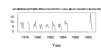
| PointID: | 74 | Code: | 05AC029 | Latitude (decimal degrees): | 49.90 | Longitude (decimal degrees): | -113.18 | Drainage Area (km2): | Source: | Hydat | Hydrological Zone: | Nelson | Name: | LETHBRIDGE NORTHERN IRRIGATION DISTRICT CANAL BELOW MONARCH HEADGATES |
|---|
| Download | |
|---|---|
| Site Descriptor Information | Site Time Series Data |
| Link to all available data | |
| ID | Year | Jan | Feb | Mar | Apr | May | Jun | Jul | Aug | Sep | Oct | Nov | Dec |
|---|---|---|---|---|---|---|---|---|---|---|---|---|---|
| 74 | 1977 | 7.00 | 9.39 | 6.10 | 3.37 | 8.57 | 9.12 | 2.09 | |||||
| 74 | 1978 | 9.56 | 7.87 | 7.40 | 0.83 | 0.71 | |||||||
| 74 | 1979 | 3.47 | 7.67 | 5.43 | 10.10 | 8.06 | 3.17 | ||||||
| 74 | 1980 | 5.00 | 6.79 | 2.53 | 5.16 | 7.15 | 3.66 | 2.50 | |||||
| 74 | 1981 | 4.00 | 6.47 | 4.60 | 7.29 | 6.99 | 4.07 | 3.62 | |||||
| 74 | 1982 | 1.00 | 9.92 | 6.91 | 5.56 | 6.79 | 5.64 | 0.00 | |||||
| 74 | 1983 | 4.00 | 7.80 | 3.58 | 7.54 | 6.66 | 4.74 | 0.67 | |||||
| 74 | 1984 | 7.00 | 11.10 | 7.39 | 8.31 | 7.32 | 8.02 | 0.01 | |||||
| 74 | 1988 | 8.00 | 18.70 | 14.20 | 4.54 | 3.29 | 1.59 | 1.54 |
 Return to R-Arctic Net Home Page