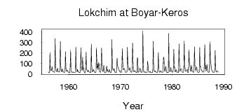
Lokchim at Boyar-Keros
North European Russia
| PointID: | 7398 |
Code: | 70215 |
Latitude (decimal degrees): | 61.58 |
Longitude (decimal degrees): | 51.58 |
Drainage Area (km2): | 6040.00 |
Source: | SHI |
Hydrological Zone: | North European Russia |
Name: | Lokchim at Boyar-Keros |
Field Definitions
Site Time Series Plot:
Site Data File:
(Units: m3/s)
| ID | Year | Jan | Feb | Mar | Apr | May | Jun | Jul | Aug | Sep | Oct | Nov | Dec |
|---|
| 7398 | 1956 | 19.80 | 13.00 | 12.90 | 15.40 | 205.00 | 47.10 | 29.50 | 32.50 | 44.00 | 70.50 | 30.10 | 23.10 |
| 7398 | 1957 | 22.30 | 20.00 | 16.90 | 19.20 | 338.00 | 113.00 | 38.20 | 24.70 | 21.80 | 46.80 | 57.20 | 21.50 |
| 7398 | 1958 | 22.10 | 19.20 | 18.70 | 37.90 | 309.00 | 82.80 | 30.60 | 23.90 | 22.40 | 49.00 | 35.70 | 21.50 |
| 7398 | 1959 | 17.40 | 16.20 | 16.00 | 42.90 | 213.00 | 57.20 | 36.70 | 23.80 | 37.00 | 33.20 | 22.10 | 13.80 |
| 7398 | 1960 | 13.20 | 12.70 | 12.80 | 65.30 | 226.00 | 37.90 | 19.50 | 17.10 | 16.40 | 21.60 | 15.00 | 15.20 |
| 7398 | 1961 | 14.80 | 13.70 | 13.60 | 17.00 | 257.00 | 67.50 | 40.60 | 21.00 | 45.00 | 25.10 | 27.20 | 16.60 |
| 7398 | 1962 | 14.50 | 15.10 | 14.70 | 102.00 | 249.00 | 53.70 | 36.40 | 37.00 | 161.00 | 49.50 | 60.90 | 26.20 |
| 7398 | 1963 | 14.50 | 12.00 | 13.10 | 46.50 | 208.00 | 48.10 | 39.50 | 27.70 | 21.20 | 35.40 | 31.90 | 24.30 |
| 7398 | 1964 | 18.40 | 15.20 | 13.30 | 17.00 | 286.00 | 85.30 | 25.30 | 22.20 | 28.70 | 46.70 | 33.50 | 23.30 |
| 7398 | 1965 | 17.10 | 15.00 | 14.20 | 23.50 | 250.00 | 115.00 | 56.00 | 94.40 | 41.90 | 108.00 | 94.10 | 25.60 |
| 7398 | 1966 | 19.90 | 18.90 | 17.90 | 101.00 | 247.00 | 76.50 | 31.80 | 24.00 | 41.90 | 84.00 | 30.20 | 14.30 |
| 7398 | 1967 | 13.20 | 13.20 | 13.20 | 53.80 | 76.90 | 28.00 | 42.90 | 22.50 | 17.30 | 28.10 | 44.00 | 22.80 |
| 7398 | 1968 | 16.90 | 14.50 | 15.30 | 33.50 | 328.00 | 63.00 | 48.50 | 41.80 | 34.70 | 53.20 | 24.80 | 18.20 |
| 7398 | 1969 | 16.50 | 13.50 | 13.70 | 46.50 | 153.00 | 74.70 | 69.20 | 54.00 | 39.20 | 32.90 | 25.10 | 32.40 |
| 7398 | 1970 | 15.40 | 15.60 | 16.50 | 37.90 | 242.00 | 129.00 | 43.80 | 40.90 | 53.20 | 50.80 | 38.50 | 19.60 |
| 7398 | 1971 | 16.70 | 17.80 | 16.70 | 24.10 | 255.00 | 101.00 | 80.70 | 39.50 | 37.60 | 49.20 | 60.20 | 31.80 |
| 7398 | 1972 | 20.20 | 16.70 | 16.60 | 41.60 | 294.00 | 117.00 | 39.90 | 20.20 | 26.20 | 33.60 | 27.60 | 23.10 |
| 7398 | 1973 | 17.10 | 14.20 | 14.30 | 151.00 | 155.00 | 22.70 | 16.30 | 24.10 | 32.50 | 56.80 | 46.00 | 21.80 |
| 7398 | 1974 | 18.10 | 16.00 | 16.20 | 51.80 | 411.00 | 98.00 | 24.10 | 17.70 | 18.70 | 21.30 | 19.00 | 14.70 |
| 7398 | 1975 | 14.80 | 15.00 | 15.10 | 122.00 | 81.90 | 28.00 | 25.30 | 16.60 | 21.00 | 25.50 | 16.40 | 14.60 |
| 7398 | 1976 | 14.70 | 12.50 | 14.80 | 27.60 | 311.00 | 94.00 | 36.70 | 21.90 | 28.90 | 31.20 | 19.10 | 19.10 |
| 7398 | 1977 | 17.00 | 15.10 | 15.90 | 71.70 | 205.00 | 31.40 | 23.30 | 16.90 | 19.10 | 32.40 | 28.70 | 22.80 |
| 7398 | 1978 | 17.00 | 15.00 | 15.20 | 49.20 | 164.00 | 145.00 | 33.20 | 27.00 | 28.60 | 74.60 | 50.60 | 22.40 |
| 7398 | 1979 | 12.90 | 16.30 | 16.90 | 13.40 | 385.00 | 58.30 | 27.50 | 22.20 | 31.20 | 65.40 | 31.60 | 22.50 |
| 7398 | 1980 | 22.50 | 18.40 | 16.90 | 66.20 | 236.00 | 59.10 | 68.90 | 20.80 | 29.00 | 40.80 | 37.00 | 17.10 |
| 7398 | 1981 | 18.70 | 18.40 | 16.00 | 15.80 | 287.00 | 95.50 | 24.00 | 37.10 | 47.20 | 48.40 | 46.70 | 26.10 |
| 7398 | 1982 | 18.10 | 16.50 | 16.50 | 23.90 | 313.00 | 90.30 | 56.20 | 34.20 | 25.80 | 27.90 | 37.00 | 46.50 |
| 7398 | 1983 | 17.50 | 13.80 | 18.00 | 231.00 | 121.00 | 94.20 | 65.70 | 29.40 | 27.50 | 82.30 | 47.60 | 22.90 |
| 7398 | 1984 | 23.40 | 17.60 | 17.30 | 40.00 | 259.00 | 69.10 | 53.30 | 31.40 | 58.60 | 69.00 | 43.80 | 21.50 |
| 7398 | 1985 | 15.40 | 15.50 | 15.00 | 20.90 | 253.00 | 68.90 | 74.60 | 48.00 | 35.80 | 40.20 | 23.20 | 19.10 |
| 7398 | 1986 | 18.90 | 18.80 | 19.70 | 119.00 | 280.00 | 48.60 | 84.00 | 28.80 | 44.50 | 92.30 | 50.10 | 25.40 |
| 7398 | 1987 | 15.20 | 17.50 | 19.10 | 24.70 | 305.00 | 105.00 | 106.00 | 59.30 | 39.40 | 38.50 | 21.30 | 16.60 |
| 7398 | 1988 | 16.90 | 16.50 | 17.80 | 49.70 | 225.00 | 69.20 | 24.90 | 18.10 | 27.40 | 27.30 | 26.40 | 16.50 |
 Return to R-Arctic Net Home Page