| PointID: | 7383 | Code: | 70174 | Latitude (decimal degrees): | 60.93 | Longitude (decimal degrees): | 46.53 | Drainage Area (km2): | 29.39 | Source: | SHI | Hydrological Zone: | North European Russia | Name: | Savatievka at Gorbitshevo |
|---|
| Download | |
|---|---|
| Site Descriptor Information | Site Time Series Data |
| Link to all available data | |
| ID | Year | Jan | Feb | Mar | Apr | May | Jun | Jul | Aug | Sep | Oct | Nov | Dec |
|---|---|---|---|---|---|---|---|---|---|---|---|---|---|
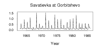
| 7383 | 1962 | 0.09 | |||||||||||
| 7383 | 1963 | 0.13 | 0.14 | 0.11 | 0.57 | 0.39 | 0.23 | 0.20 | 0.10 | 0.08 | 0.12 | 0.13 | 0.11 |
| 7383 | 1964 | 0.11 | 0.12 | 0.15 | 0.28 | 0.95 | 0.16 | 0.12 | 0.10 | 0.12 | 0.13 | 0.16 | 0.12 |
| 7383 | 1965 | 0.08 | 0.07 | 0.08 | 0.30 | 0.72 | 0.40 | 0.15 | 0.13 | 0.10 | 0.19 | 0.19 | 0.14 |
| 7383 | 1966 | 0.11 | 0.10 | 0.10 | 1.11 | 0.73 | 0.17 | 0.11 | 0.09 | 0.11 | 0.13 | 0.11 | 0.08 |
| 7383 | 1967 | 0.03 | 4.0e-03 | 0.08 | 0.25 | 0.15 | 0.11 | 0.08 | 0.07 | 0.07 | 0.09 | 0.11 | 0.08 |
| 7383 | 1968 | 0.07 | 0.07 | 0.07 | 0.22 | 1.55 | 0.20 | 0.16 | 0.15 | 0.12 | 0.17 | 0.13 | 0.09 |
| 7383 | 1969 | 0.11 | 0.05 | 0.07 | 0.54 | 0.52 | 0.21 | 0.13 | 0.10 | 0.09 | 0.12 | 0.19 | 0.19 |
| 7383 | 1970 | 0.10 | 0.12 | 0.13 | 0.33 | 0.36 | 0.21 | 0.10 | 0.08 | 0.09 | 0.13 | 0.14 | 0.13 |
| 7383 | 1971 | 0.13 | 0.07 | 0.07 | 0.15 | 1.54 | 0.25 | 0.13 | 0.10 | 0.10 | 0.13 | 0.12 | 0.14 |
| 7383 | 1972 | 0.12 | 0.06 | 0.07 | 0.31 | 0.86 | 0.27 | 0.12 | 0.10 | 0.09 | 0.09 | 0.08 | 0.08 |
| 7383 | 1973 | 0.07 | 0.08 | 0.08 | 0.44 | 0.30 | 0.09 | 0.08 | 0.10 | 0.11 | 0.12 | 0.10 | 0.12 |
| 7383 | 1974 | 0.09 | 0.09 | 0.06 | 0.17 | 1.36 | 0.24 | 0.11 | 0.11 | 0.13 | 0.11 | 0.11 | 0.11 |
| 7383 | 1975 | 0.13 | 0.14 | 0.09 | 0.97 | 0.30 | 0.14 | 0.10 | 0.11 | 0.10 | 0.12 | 0.11 | 0.08 |
| 7383 | 1976 | 0.10 | 0.08 | 0.12 | 0.27 | 0.98 | 0.15 | 0.21 | 0.11 | 0.12 | 0.13 | 0.15 | 0.11 |
| 7383 | 1977 | 0.10 | 0.09 | 0.10 | 0.45 | 0.32 | 0.08 | 0.07 | 0.07 | 0.08 | 0.09 | 0.15 | 0.07 |
| 7383 | 1978 | 0.05 | 0.04 | 0.05 | 0.28 | 0.67 | 0.68 | 0.19 | 0.14 | 0.16 | 0.21 | 0.13 | 0.06 |
| 7383 | 1979 | 0.05 | 0.09 | 0.04 | 0.11 | 0.95 | 0.11 | 0.08 | 0.07 | 0.07 | 0.08 | 0.10 | 0.09 |
| 7383 | 1980 | 0.08 | 0.06 | 0.09 | 0.32 | 1.04 | 0.19 | 0.15 | 0.09 | 0.11 | 0.11 | 0.08 | 0.08 |
| 7383 | 1981 | 0.07 | 0.05 | 0.05 | 0.07 | 1.35 | 0.27 | 0.09 | 0.09 | 0.09 | 0.11 | 0.09 | 0.08 |
| 7383 | 1982 | 0.05 | 0.04 | 0.04 | 0.20 | 0.63 | 0.18 | 0.10 | 0.12 | 0.14 | 0.11 | 0.25 | 0.15 |
| 7383 | 1983 | 0.08 | 0.04 | 0.08 | 0.57 | 0.24 | 0.12 | 0.11 | 0.09 | 0.12 | 0.15 | 0.12 | 0.09 |
| 7383 | 1984 | 0.07 | 0.06 | 0.05 | 0.55 | 0.59 | 0.19 | 0.29 | 0.10 | 0.16 | 0.20 | 0.15 | 0.08 |
| 7383 | 1985 | 0.05 | 0.04 | 0.04 | 0.16 | 0.54 | 0.49 | 0.36 | 0.23 | 0.28 | 0.17 | 0.18 | 0.13 |
 Return to R-Arctic Net Home Page