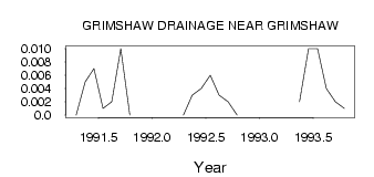
| PointID: | 737 | Code: | 07FD908 | Latitude (decimal degrees): | 56.16 | Longitude (decimal degrees): | -117.60 | Drainage Area (km2): | 8.10 | Source: | Hydat | Hydrological Zone: | Mackenzie | Name: | GRIMSHAW DRAINAGE NEAR GRIMSHAW |
|---|
| Download | |
|---|---|
| Site Descriptor Information | Site Time Series Data |
| Link to all available data | |
| ID | Year | Jan | Feb | Mar | Apr | May | Jun | Jul | Aug | Sep | Oct | Nov | Dec |
|---|---|---|---|---|---|---|---|---|---|---|---|---|---|
| 737 | 1991 | 0.00 | 5.0e-03 | 7.0e-03 | 1.0e-03 | 2.0e-03 | 0.01 | 0.00 | |||||
| 737 | 1992 | 0.00 | 3.0e-03 | 4.0e-03 | 6.0e-03 | 3.0e-03 | 2.0e-03 | 0.00 | |||||
| 737 | 1993 | 2.0e-03 | 0.01 | 0.01 | 4.0e-03 | 2.0e-03 | 1.0e-03 |
 Return to R-Arctic Net Home Page