Nurmi at Ustie
North European Russia
| PointID: | 7331 |
Code: | 49141 |
Latitude (decimal degrees): | 65.03 |
Longitude (decimal degrees): | 31.72 |
Drainage Area (km2): | 38.90 |
Source: | SHI |
Hydrological Zone: | North European Russia |
Name: | Nurmi at Ustie |
Field Definitions
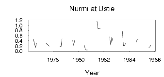
Site Time Series Plot:
Site Data File:
(Units: m3/s)
| ID | Year | Jan | Feb | Mar | Apr | May | Jun | Jul | Aug | Sep | Oct | Nov | Dec |
|---|
| 7331 | 1976 | | | | | | 0.46 | 0.30 | 0.14 | 0.30 | | | |
| 7331 | 1977 | | | | | | 0.30 | 0.26 | 0.23 | 0.19 | | | |
| 7331 | 1978 | | | | | | | 0.19 | 0.16 | 0.47 | | | |
| 7331 | 1979 | | | | | | | 0.41 | 0.22 | 0.42 | | | |
| 7331 | 1980 | | | | | | 0.23 | 0.07 | 0.04 | 0.04 | | | |
| 7331 | 1981 | | | | | | 1.16 | 0.86 | 0.89 | 0.87 | | | |
| 7331 | 1982 | | | | | | 0.55 | 0.23 | 0.54 | 0.40 | | | |
| 7331 | 1983 | | | | | | 0.78 | 0.21 | 0.21 | 0.29 | | | |
| 7331 | 1984 | | | | | | | 0.34 | 0.45 | 0.44 | | | |
| 7331 | 1985 | | | | | | | 0.13 | 0.17 | 0.24 | | | |
 Return to R-Arctic Net Home Page