Kis-Kis at Ustie
North European Russia
| PointID: | 7330 |
Code: | 49140 |
Latitude (decimal degrees): | 65.20 |
Longitude (decimal degrees): | 30.95 |
Drainage Area (km2): | 94.00 |
Source: | SHI |
Hydrological Zone: | North European Russia |
Name: | Kis-Kis at Ustie |
Field Definitions
Site Time Series Plot:
Site Data File:
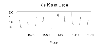
(Units: m3/s)
| ID | Year | Jan | Feb | Mar | Apr | May | Jun | Jul | Aug | Sep | Oct | Nov | Dec |
|---|
| 7330 | 1976 | | | | | | 1.19 | 0.74 | 0.43 | 0.45 | | | |
| 7330 | 1977 | | | | | | 0.96 | 0.93 | 0.73 | | | | |
| 7330 | 1978 | | | | | | | 0.69 | 0.64 | 1.47 | | | |
| 7330 | 1979 | | | | | | | 1.04 | 1.08 | 1.53 | | | |
| 7330 | 1980 | | | | | | | 0.34 | 0.25 | 0.32 | | | |
| 7330 | 1981 | | | | | | | 1.62 | 2.00 | 1.57 | | | |
| 7330 | 1982 | | | | | | 1.62 | 0.97 | 1.09 | | | | |
| 7330 | 1983 | | | | | | 2.00 | 0.86 | 0.79 | 0.76 | | | |
| 7330 | 1984 | | | | | | 0.67 | 0.74 | 1.31 | 1.62 | | | |
| 7330 | 1985 | | | | | | | 0.64 | 0.95 | 1.21 | | | |
 Return to R-Arctic Net Home Page