Nyzjnyaya Voopo at Ustie
North European Russia
| PointID: | 7329 |
Code: | 49139 |
Latitude (decimal degrees): | 64.92 |
Longitude (decimal degrees): | 31.70 |
Drainage Area (km2): | 105.00 |
Source: | SHI |
Hydrological Zone: | North European Russia |
Name: | Nyzjnyaya Voopo at Ustie |
Field Definitions
Site Time Series Plot:
Site Data File:
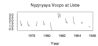
(Units: m3/s)
| ID | Year | Jan | Feb | Mar | Apr | May | Jun | Jul | Aug | Sep | Oct | Nov | Dec |
|---|
| 7329 | 1976 | | | | | | 1.94 | 1.77 | 1.05 | 1.42 | | | |
| 7329 | 1977 | | | | | | 1.84 | 1.13 | 1.24 | 0.94 | | | |
| 7329 | 1978 | | | | | | | 1.21 | 1.07 | 1.81 | | | |
| 7329 | 1979 | | | | | | | 1.93 | 1.22 | 1.48 | | | |
| 7329 | 1980 | | | | | | 1.64 | 0.85 | 0.43 | 0.37 | | | |
| 7329 | 1981 | | | | | | 3.34 | 2.43 | 2.63 | 3.18 | 2.55 | | |
| 7329 | 1982 | | | | | | 2.35 | 1.60 | 1.76 | 1.50 | | | |
| 7329 | 1983 | | | | | | 2.67 | 1.56 | 1.48 | 1.36 | | | |
| 7329 | 1984 | | | | | | | 1.44 | 1.73 | 1.49 | | | |
| 7329 | 1985 | | | | | | | 1.00 | 0.84 | 0.83 | | | |
 Return to R-Arctic Net Home Page