Olanga at Ustie
North European Russia
| PointID: | 7328 |
Code: | 49138 |
Latitude (decimal degrees): | 66.23 |
Longitude (decimal degrees): | 30.60 |
Drainage Area (km2): | 5430.00 |
Source: | SHI |
Hydrological Zone: | North European Russia |
Name: | Olanga at Ustie |
Field Definitions
Site Time Series Plot:
Site Data File:
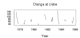
(Units: m3/s)
| ID | Year | Jan | Feb | Mar | Apr | May | Jun | Jul | Aug | Sep | Oct | Nov | Dec |
|---|
| 7328 | 1977 | | | | | | 136.00 | 90.10 | 77.20 | 45.00 | 47.10 | | |
| 7328 | 1978 | | | | | | | 46.60 | 38.20 | 68.30 | 67.90 | | |
| 7328 | 1979 | | | | | | | 77.90 | 58.30 | 76.20 | | | |
| 7328 | 1980 | | | | | | | 38.70 | 40.00 | 33.60 | | | |
| 7328 | 1981 | | | | | | | 117.00 | 107.00 | 92.20 | 73.10 | | |
| 7328 | 1982 | | | | | | | 79.40 | 57.80 | 94.90 | 66.70 | | |
| 7328 | 1983 | | | | | | 149.00 | 76.00 | 50.90 | 41.10 | | | |
| 7328 | 1984 | | | | | | 75.00 | 66.70 | 69.70 | 61.60 | | | |
| 7328 | 1985 | | | | | | | 59.70 | 47.20 | 64.80 | 94.30 | | |
 Return to R-Arctic Net Home Page