Tavo-Yoki at Ustie
North European Russia
| PointID: | 7327 |
Code: | 49137 |
Latitude (decimal degrees): | 66.08 |
Longitude (decimal degrees): | 30.62 |
Drainage Area (km2): | 312.00 |
Source: | SHI |
Hydrological Zone: | North European Russia |
Name: | Tavo-Yoki at Ustie |
Field Definitions
Site Time Series Plot:
Site Data File:
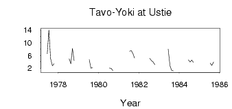
(Units: m3/s)
| ID | Year | Jan | Feb | Mar | Apr | May | Jun | Jul | Aug | Sep | Oct | Nov | Dec |
|---|
| 7327 | 1977 | | | | | | 6.57 | 14.00 | 5.08 | 2.78 | 3.36 | | |
| 7327 | 1978 | | | | | | | 4.96 | 3.36 | 8.22 | 4.42 | | |
| 7327 | 1979 | | | | | | | 4.69 | 1.98 | 2.20 | | | |
| 7327 | 1980 | | | | | | | 2.03 | 1.96 | 1.26 | | | |
| 7327 | 1981 | | | | | | | 7.33 | 7.55 | 6.59 | 5.18 | | |
| 7327 | 1982 | | | | | | | 5.06 | 4.40 | 3.99 | 3.11 | | |
| 7327 | 1983 | | | | | | 7.98 | 2.75 | 1.33 | 1.16 | | | |
| 7327 | 1984 | | | | | | 4.59 | 3.92 | 4.56 | 3.86 | | | |
| 7327 | 1985 | | | | | | | 3.57 | 2.85 | 3.93 | | | |
 Return to R-Arctic Net Home Page