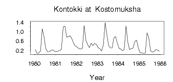
Kontokki at Kostomuksha
North European Russia
| PointID: | 7325 |
Code: | 49135 |
Latitude (decimal degrees): | 64.57 |
Longitude (decimal degrees): | 30.62 |
Drainage Area (km2): | 39.40 |
Source: | SHI |
Hydrological Zone: | North European Russia |
Name: | Kontokki at Kostomuksha |
Field Definitions
Site Time Series Plot:
Site Data File:
(Units: m3/s)
| ID | Year | Jan | Feb | Mar | Apr | May | Jun | Jul | Aug | Sep | Oct | Nov | Dec |
|---|
| 7325 | 1980 | 0.24 | 0.08 | 0.09 | 0.18 | 1.12 | 0.80 | 0.29 | 0.15 | 0.15 | 0.20 | 0.23 | 0.17 |
| 7325 | 1981 | 0.15 | 0.17 | 0.20 | 0.25 | 1.21 | 1.23 | 0.76 | 0.79 | 0.83 | 0.69 | 0.50 | 0.39 |
| 7325 | 1982 | 0.35 | 0.28 | 0.27 | 0.29 | 1.26 | 0.64 | 0.45 | 0.32 | 0.51 | 0.41 | 0.50 | 0.46 |
| 7325 | 1983 | 0.32 | 0.28 | 0.18 | 0.45 | 1.39 | 0.88 | 0.42 | 0.31 | 0.31 | 0.74 | 0.79 | 0.51 |
| 7325 | 1984 | 0.29 | 0.26 | 0.19 | 0.25 | 1.24 | 0.54 | 0.24 | 0.28 | 0.30 | 0.59 | 0.64 | 0.31 |
| 7325 | 1985 | 0.12 | 0.09 | 0.08 | 0.08 | 0.95 | 0.75 | 0.18 | 0.14 | 0.15 | 0.24 | 0.22 | 0.17 |
 Return to R-Arctic Net Home Page