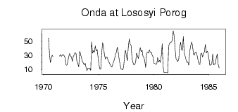
Onda at Lososyi Porog
North European Russia
| PointID: | 7311 |
Code: | 49110 |
Latitude (decimal degrees): | 63.87 |
Longitude (decimal degrees): | 34.13 |
Drainage Area (km2): | 3360.00 |
Source: | SHI |
Hydrological Zone: | North European Russia |
Name: | Onda at Lososyi Porog |
Field Definitions
Site Time Series Plot:
Site Data File:
(Units: m3/s)
| ID | Year | Jan | Feb | Mar | Apr | May | Jun | Jul | Aug | Sep | Oct | Nov | Dec |
|---|
| 7311 | 1970 | | | | | | 54.40 | 32.30 | 19.70 | 25.50 | 30.00 | 28.20 | |
| 7311 | 1971 | | | | | | 28.70 | 31.00 | 28.50 | 29.70 | 31.10 | 29.80 | 27.00 |
| 7311 | 1972 | 16.60 | 15.90 | 20.40 | 27.30 | 32.70 | 29.00 | 27.80 | 21.50 | 28.40 | 30.70 | 33.70 | 32.60 |
| 7311 | 1973 | 21.60 | 17.80 | 13.90 | 35.80 | 31.30 | 27.00 | 21.10 | 19.10 | 16.50 | 18.80 | 12.20 | 8.26 |
| 7311 | 1974 | 11.60 | 11.30 | 11.70 | 8.95 | 49.00 | 33.00 | 36.70 | 34.40 | 43.30 | 36.00 | 38.20 | 28.20 |
| 7311 | 1975 | 16.20 | 10.80 | 10.30 | 33.10 | 47.90 | 42.10 | 30.90 | 24.80 | 27.90 | 27.20 | 23.00 | 20.40 |
| 7311 | 1976 | 17.10 | 15.20 | 13.30 | 17.00 | 20.40 | 25.00 | 31.30 | 34.50 | 41.70 | 34.30 | 24.80 | 18.00 |
| 7311 | 1977 | 10.80 | 10.20 | 9.66 | 14.00 | 31.70 | 37.10 | 29.60 | 22.30 | 40.80 | 53.30 | 45.90 | 43.70 |
| 7311 | 1978 | 26.60 | 20.40 | 16.50 | 16.40 | 20.70 | 33.20 | 29.10 | 25.40 | 33.20 | 40.90 | 35.20 | 37.40 |
| 7311 | 1979 | 28.70 | 26.60 | 21.70 | 12.80 | 33.10 | 34.20 | 33.10 | 37.80 | 34.50 | 34.70 | 30.40 | 27.80 |
| 7311 | 1980 | 18.80 | 18.30 | 17.50 | 17.80 | 27.00 | 20.50 | 22.90 | 19.90 | 30.10 | 46.30 | 14.20 | 5.40 |
| 7311 | 1981 | 5.46 | 5.39 | 5.56 | 5.19 | 43.20 | 46.40 | 48.50 | 48.80 | 51.00 | 64.80 | 57.30 | 39.70 |
| 7311 | 1982 | 25.00 | 23.10 | 21.20 | 24.70 | 41.00 | 48.50 | 39.00 | 36.90 | 56.70 | 33.90 | 28.50 | 23.80 |
| 7311 | 1983 | 19.90 | 20.70 | 15.90 | 35.60 | 43.10 | 48.80 | 44.20 | 31.50 | 30.20 | 34.10 | 34.60 | 30.30 |
| 7311 | 1984 | 23.40 | 18.20 | 17.00 | 32.00 | 33.20 | 27.60 | 32.70 | 34.90 | 45.50 | 33.30 | 36.00 | 33.90 |
| 7311 | 1985 | 24.40 | 15.80 | 16.60 | 17.50 | 32.00 | 16.50 | 17.90 | 17.70 | 26.60 | 31.90 | 17.60 | 12.10 |
 Return to R-Arctic Net Home Page