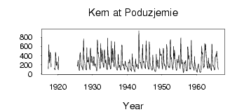
Kem at Poduzjemie
North European Russia
| PointID: | 7282 |
Code: | 49039 |
Latitude (decimal degrees): | 64.90 |
Longitude (decimal degrees): | 34.30 |
Drainage Area (km2): | 27900.00 |
Source: | SHI |
Hydrological Zone: | North European Russia |
Name: | Kem at Poduzjemie |
Field Definitions
Site Time Series Plot:
Site Data File:
(Units: m3/s)
| ID | Year | Jan | Feb | Mar | Apr | May | Jun | Jul | Aug | Sep | Oct | Nov | Dec |
|---|
| 7282 | 1917 | | | | 114.00 | 381.00 | 636.00 | 426.00 | 246.00 | 303.00 | 463.00 | 471.00 | 398.00 |
| 7282 | 1918 | 309.00 | 155.00 | | | | | | | | | | |
| 7282 | 1919 | 129.00 | 108.00 | 93.00 | 92.00 | 471.00 | 437.00 | 313.00 | 196.00 | 188.00 | 256.00 | 264.00 | 156.00 |
| 7282 | 1920 | 124.00 | 103.00 | 92.00 | 384.00 | | | | | | | | |
| 7282 | 1925 | | | | | | | | 186.00 | 167.00 | 202.00 | 302.00 | 204.00 |
| 7282 | 1926 | 127.00 | 108.00 | 81.00 | 76.00 | 440.00 | 436.00 | 468.00 | 266.00 | 219.00 | 191.00 | 170.00 | 148.00 |
| 7282 | 1927 | 158.00 | 112.00 | 94.00 | 83.00 | 483.00 | 766.00 | 461.00 | 296.00 | 286.00 | 243.00 | 193.00 | 149.00 |
| 7282 | 1928 | 114.00 | 100.00 | 90.00 | 89.00 | 575.00 | 371.00 | 258.00 | 283.00 | 290.00 | 264.00 | 371.00 | 258.00 |
| 7282 | 1929 | 206.00 | 172.00 | 121.00 | 93.00 | 509.00 | 565.00 | 311.00 | 245.00 | 371.00 | 389.00 | 362.00 | 269.00 |
| 7282 | 1930 | 251.00 | 275.00 | 178.00 | 205.00 | 376.00 | 370.00 | 215.00 | 171.00 | 206.00 | 202.00 | 224.00 | 179.00 |
| 7282 | 1931 | 145.00 | 110.00 | 69.00 | 68.00 | 580.00 | 745.00 | 639.00 | 437.00 | 472.00 | 392.00 | 357.00 | 261.00 |
| 7282 | 1932 | 211.00 | 144.00 | 115.00 | 155.00 | 668.00 | 514.00 | 373.00 | 265.00 | 310.00 | 523.00 | 433.00 | 353.00 |
| 7282 | 1933 | 229.00 | 172.00 | 138.00 | 146.00 | 476.00 | 526.00 | 500.00 | 420.00 | 254.00 | 238.00 | 308.00 | 231.00 |
| 7282 | 1934 | 149.00 | 118.00 | 97.00 | 95.00 | 779.00 | 519.00 | 378.00 | 263.00 | 199.00 | 285.00 | 368.00 | 283.00 |
| 7282 | 1935 | 189.00 | 141.00 | 107.00 | 118.00 | 427.00 | 714.00 | 345.00 | 249.00 | 274.00 | 558.00 | 545.00 | 370.00 |
| 7282 | 1936 | 264.00 | 239.00 | 176.00 | 152.00 | 699.00 | 480.00 | 320.00 | 249.00 | 193.00 | 156.00 | 150.00 | 110.00 |
| 7282 | 1937 | 95.40 | 85.40 | 84.40 | 168.00 | 428.00 | 403.00 | 220.00 | 158.00 | 133.00 | 189.00 | 185.00 | 132.00 |
| 7282 | 1938 | 108.00 | 87.50 | 82.70 | 109.00 | 582.00 | 634.00 | 611.00 | 307.00 | 205.00 | 179.00 | 193.00 | 213.00 |
| 7282 | 1939 | 148.00 | 122.00 | 107.00 | 91.10 | 267.00 | 282.00 | 230.00 | 198.00 | 170.00 | 174.00 | 160.00 | 147.00 |
| 7282 | 1940 | 113.00 | 103.00 | 73.90 | 52.10 | 258.00 | 246.00 | 238.00 | 250.00 | 319.00 | 278.00 | 127.00 | 96.00 |
| 7282 | 1941 | 107.00 | 81.20 | 69.00 | 59.50 | 202.00 | 438.00 | 271.00 | 173.00 | 191.00 | 168.00 | 119.00 | 93.50 |
| 7282 | 1942 | 79.00 | 58.20 | 43.90 | 89.90 | 268.00 | 330.00 | 225.00 | 167.00 | 152.00 | 194.00 | 211.00 | 178.00 |
| 7282 | 1943 | 145.00 | 126.00 | 108.00 | 196.00 | 943.00 | 670.00 | 350.00 | 269.00 | 234.00 | 254.00 | 248.00 | 204.00 |
| 7282 | 1944 | 149.00 | 137.00 | 123.00 | 111.00 | 508.00 | 647.00 | 369.00 | 243.00 | 278.00 | 277.00 | 249.00 | 193.00 |
| 7282 | 1945 | 155.00 | 147.00 | 128.00 | 117.00 | 490.00 | 726.00 | 583.00 | 280.00 | 282.00 | 272.00 | 216.00 | 155.00 |
| 7282 | 1946 | 143.00 | 118.00 | 104.00 | 107.00 | 699.00 | 583.00 | 370.00 | 239.00 | 186.00 | 168.00 | 146.00 | 121.00 |
| 7282 | 1947 | 102.00 | 89.90 | 80.30 | 110.00 | 412.00 | 280.00 | 186.00 | 141.00 | 117.00 | 107.00 | 91.90 | 65.30 |
| 7282 | 1948 | 61.10 | 55.70 | 50.50 | 151.00 | 429.00 | 319.00 | 210.00 | 151.00 | 176.00 | 306.00 | 296.00 | 263.00 |
| 7282 | 1949 | 183.00 | 133.00 | 112.00 | 223.00 | 561.00 | 462.00 | 403.00 | 430.00 | 410.00 | 399.00 | 432.00 | 263.00 |
| 7282 | 1950 | 189.00 | 129.00 | 102.00 | 286.00 | 561.00 | 550.00 | 429.00 | 251.00 | 178.00 | 207.00 | 196.00 | 172.00 |
| 7282 | 1951 | 140.00 | 116.00 | 86.30 | 220.00 | 644.00 | 583.00 | 468.00 | 292.00 | 201.00 | 196.00 | 159.00 | 142.00 |
| 7282 | 1952 | 160.00 | 152.00 | 131.00 | 156.00 | 695.00 | 746.00 | 420.00 | 317.00 | 360.00 | 343.00 | 227.00 | 174.00 |
| 7282 | 1953 | 132.00 | 108.00 | 96.60 | 243.00 | 600.00 | 504.00 | 329.00 | 514.00 | 425.00 | 344.00 | 260.00 | 189.00 |
| 7282 | 1954 | 155.00 | 94.60 | 76.60 | 101.00 | 324.00 | 275.00 | 266.00 | 245.00 | 257.00 | 354.00 | 409.00 | 282.00 |
| 7282 | 1955 | 220.00 | 166.00 | 130.00 | 112.00 | 587.00 | 789.00 | 458.00 | 289.00 | 219.00 | 241.00 | 303.00 | 169.00 |
| 7282 | 1956 | 123.00 | 70.50 | 24.30 | 46.10 | 258.00 | 215.00 | 235.00 | 232.00 | 260.00 | 293.00 | 192.00 | 72.40 |
| 7282 | 1957 | 81.60 | 83.80 | 66.00 | 76.40 | 577.00 | 592.00 | 505.00 | 324.00 | 363.00 | 407.00 | 316.00 | 162.00 |
| 7282 | 1958 | 105.00 | 125.00 | 122.00 | 101.00 | 397.00 | 734.00 | 497.00 | 340.00 | 224.00 | 198.00 | 188.00 | 144.00 |
| 7282 | 1959 | 145.00 | 128.00 | 101.00 | 75.90 | 382.00 | 269.00 | 220.00 | 147.00 | 128.00 | 124.00 | 90.90 | 62.80 |
| 7282 | 1960 | 67.80 | 39.20 | 35.10 | 110.00 | 179.00 | 198.00 | 218.00 | 158.00 | 115.00 | 85.20 | 52.60 | 45.10 |
| 7282 | 1961 | 31.60 | 38.50 | 46.10 | 48.60 | 418.00 | 609.00 | 470.00 | 430.00 | 469.00 | 337.00 | 278.00 | 127.00 |
| 7282 | 1962 | 156.00 | 171.00 | 157.00 | 346.00 | 667.00 | 515.00 | 647.00 | 589.00 | 512.00 | 383.00 | 354.00 | 236.00 |
| 7282 | 1963 | 157.00 | 159.00 | 119.00 | 117.00 | 349.00 | 253.00 | 207.00 | 126.00 | 138.00 | 228.00 | 200.00 | 198.00 |
| 7282 | 1964 | 138.00 | 111.00 | 87.10 | 73.00 | 651.00 | 636.00 | 366.00 | 209.00 | 165.00 | 194.00 | 157.00 | 143.00 |
| 7282 | 1965 | 113.00 | 88.90 | 91.10 | 140.00 | 365.00 | 371.00 | 407.00 | 427.00 | 377.00 | 497.00 | 413.00 | 336.00 |
| 7282 | 1966 | 208.00 | 152.00 | 98.60 | | | | | | | | | |
| Other Close Sites |
|---|
| PointID |
Latitude |
Longitude | Drainage Area | Source |
Name |
|---|
| 7283 | 64.93 | 34.48 | 27700.00 | SHI | Kem at Putkinskaya GES |
 Return to R-Arctic Net Home Page