| PointID: | 728 | Code: | 07DD003 | Latitude (decimal degrees): | 58.42 | Longitude (decimal degrees): | -111.55 | Drainage Area (km2): | Source: | Hydat | Hydrological Zone: | Mackenzie | Name: | EMBARRAS RIVER BELOW DIVERGENCE |
|---|
| Download | |
|---|---|
| Site Descriptor Information | Site Time Series Data |
| Link to all available data | |
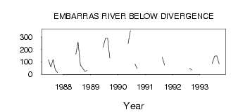
| ID | Year | Jan | Feb | Mar | Apr | May | Jun | Jul | Aug | Sep | Oct | Nov | Dec |
|---|---|---|---|---|---|---|---|---|---|---|---|---|---|
| 728 | 1987 | 117.00 | 56.50 | 118.00 | 35.80 | 10.00 | |||||||
| 728 | 1988 | 161.00 | 259.00 | 71.30 | 48.20 | 21.10 | 30.00 | ||||||
| 728 | 1989 | 216.00 | 289.00 | 289.00 | 130.00 | ||||||||
| 728 | 1990 | 247.00 | 351.00 | 81.80 | 44.70 | ||||||||
| 728 | 1991 | 137.00 | 72.50 | ||||||||||
| 728 | 1992 | 45.50 | 32.90 | ||||||||||
| 728 | 1993 | 86.80 | 145.00 | 148.00 | 82.90 |
 Return to R-Arctic Net Home Page