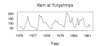
Kem at Yuryahmya
North European Russia
| PointID: | 7279 |
Code: | 49034 |
Latitude (decimal degrees): | 64.83 |
Longitude (decimal degrees): | 32.03 |
Drainage Area (km2): | 10300.00 |
Source: | SHI |
Hydrological Zone: | North European Russia |
Name: | Kem at Yuryahmya |
Field Definitions
Site Time Series Plot:
Site Data File:
(Units: m3/s)
| ID | Year | Jan | Feb | Mar | Apr | May | Jun | Jul | Aug | Sep | Oct | Nov | Dec |
|---|
| 7279 | 1976 | 69.00 | 59.60 | 50.90 | 39.80 | 42.50 | 101.00 | 115.00 | 174.00 | 117.00 | 83.80 | 66.10 | 64.40 |
| 7279 | 1977 | 60.10 | 54.50 | 48.10 | 31.50 | 68.00 | 188.00 | 166.00 | 174.00 | 127.00 | 104.00 | 109.00 | 110.00 |
| 7279 | 1978 | 90.50 | 72.40 | 59.30 | 44.40 | 41.80 | 94.80 | 103.00 | 130.00 | 115.00 | 124.00 | 95.00 | 87.10 |
| 7279 | 1979 | 85.50 | 84.30 | 71.70 | 54.90 | 119.00 | 212.00 | 196.00 | 192.00 | 131.00 | 104.00 | 161.00 | 96.60 |
| 7279 | 1980 | 57.40 | 57.20 | 85.30 | 153.00 | 79.60 | 135.00 | 129.00 | 152.00 | 154.00 | 71.30 | 63.50 | 61.10 |
| 7279 | 1981 | 63.40 | 91.70 | 55.40 | | | | | | | | | |
| Other Close Sites |
|---|
| PointID |
Latitude |
Longitude | Drainage Area | Source |
Name |
|---|
| 7280 | 64.78 | 32.17 | 19800.00 | SHI | Kem at Yushkozero |
 Return to R-Arctic Net Home Page