Pueta at Kem
North European Russia
| PointID: | 7278 |
Code: | 49033 |
Latitude (decimal degrees): | 64.95 |
Longitude (decimal degrees): | 34.62 |
Drainage Area (km2): | 48.00 |
Source: | SHI |
Hydrological Zone: | North European Russia |
Name: | Pueta at Kem |
Field Definitions
Site Time Series Plot:
Site Data File:
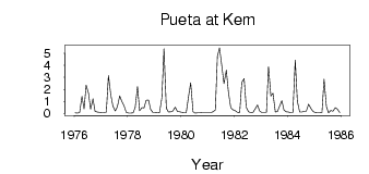
(Units: m3/s)
| ID | Year | Jan | Feb | Mar | Apr | May | Jun | Jul | Aug | Sep | Oct | Nov | Dec |
|---|
| 7278 | 1976 | 0.04 | 0.03 | 0.06 | 1.42 | 0.37 | 2.36 | 1.68 | 0.36 | 1.22 | 0.16 | 0.12 | 0.09 |
| 7278 | 1977 | 0.07 | 0.06 | 0.11 | 3.16 | 1.55 | 0.61 | 0.20 | 0.54 | 1.45 | 1.00 | 0.61 | 0.09 |
| 7278 | 1978 | 0.03 | 0.02 | 0.05 | 0.49 | 2.25 | 0.22 | 0.49 | 0.46 | 1.09 | 1.12 | 0.34 | 0.08 |
| 7278 | 1979 | 0.06 | 0.04 | 0.06 | 1.31 | 5.39 | 0.43 | 0.12 | 0.13 | 0.20 | 0.53 | 0.17 | 0.13 |
| 7278 | 1980 | 0.09 | 0.06 | 0.06 | 1.43 | 2.55 | 0.13 | 0.03 | 0.04 | 0.04 | 0.06 | 0.06 | 0.08 |
| 7278 | 1981 | 0.06 | 0.07 | 0.13 | 0.28 | 4.75 | 5.46 | 3.91 | 2.48 | 3.58 | 1.77 | 0.47 | 0.31 |
| 7278 | 1982 | 0.23 | 0.09 | 0.08 | 2.58 | 2.90 | 0.50 | 0.13 | 0.08 | 0.10 | 0.37 | 0.70 | 0.20 |
| 7278 | 1983 | 0.07 | 0.06 | 0.07 | 3.88 | 1.43 | 1.67 | 0.12 | 0.15 | 0.59 | 1.06 | 0.27 | 0.13 |
| 7278 | 1984 | 0.11 | 0.07 | 0.08 | 4.44 | 1.02 | 0.11 | 0.11 | 0.17 | 0.18 | 0.77 | 0.43 | 0.15 |
| 7278 | 1985 | 0.06 | 0.04 | 0.05 | 0.07 | 2.85 | 0.58 | 0.05 | 0.24 | 0.17 | 0.49 | 0.36 | 0.07 |
 Return to R-Arctic Net Home Page