Iset at Dolmatovo
Ob
| PointID: | 7263 |
Code: | 12615 |
Latitude (decimal degrees): | 56.25 |
Longitude (decimal degrees): | 62.92 |
Drainage Area (km2): | 13100.00 |
Source: | SHI |
Hydrological Zone: | Ob |
Name: | Iset at Dolmatovo |
Field Definitions
Site Time Series Plot:
Site Data File:
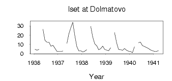
(Units: m3/s)
| ID | Year | Jan | Feb | Mar | Apr | May | Jun | Jul | Aug | Sep | Oct | Nov | Dec |
|---|
| 7263 | 1936 | 4.70 | 3.70 | 4.60 | | 26.50 | 14.40 | 12.30 | 12.30 | 8.00 | 9.00 | 5.80 | 2.50 |
| 7263 | 1937 | 2.30 | 2.40 | 2.80 | | 11.00 | 21.50 | 28.00 | 34.00 | 19.40 | 7.70 | 3.00 | 3.20 |
| 7263 | 1938 | 1.70 | 2.60 | 4.20 | | 29.60 | 18.10 | 10.50 | 8.50 | 4.20 | 5.30 | 8.20 | 4.60 |
| 7263 | 1939 | 3.80 | 3.20 | 6.30 | | 22.80 | 11.70 | 4.50 | 4.30 | 3.60 | 5.50 | 3.70 | 2.60 |
| 7263 | 1940 | 2.20 | 1.00 | 7.30 | | 11.90 | 12.50 | 8.70 | 7.70 | 6.70 | 5.60 | 4.10 | 3.10 |
| 7263 | 1941 | 2.50 | 2.40 | 3.20 | | | | | | | | | |
| Other Close Sites |
|---|
| PointID |
Latitude |
Longitude | Drainage Area | Source |
Name |
|---|
| 7182 | 56.28 | 62.58 | 12800.00 | SHI | Iset at Kataisk |
 Return to R-Arctic Net Home Page