Kunara at Bikovo
Ob
| PointID: | 7262 |
Code: | 12614 |
Latitude (decimal degrees): | 61.93 |
Longitude (decimal degrees): | 56.12 |
Drainage Area (km2): | 380.20 |
Source: | SHI |
Hydrological Zone: | Ob |
Name: | Kunara at Bikovo |
Field Definitions
Site Time Series Plot:
Site Data File:
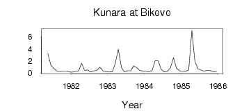
(Units: m3/s)
| ID | Year | Jan | Feb | Mar | Apr | May | Jun | Jul | Aug | Sep | Oct | Nov | Dec |
|---|
| 7262 | 1981 | | | | | 3.25 | 1.31 | 0.72 | 0.32 | 0.27 | 0.32 | 0.31 | 0.19 |
| 7262 | 1982 | 0.14 | 0.29 | 0.34 | 1.62 | 0.46 | 0.52 | 0.17 | 0.34 | 0.47 | 0.98 | 0.35 | 0.26 |
| 7262 | 1983 | 0.18 | 0.21 | 1.61 | 3.98 | 0.92 | 0.19 | 0.38 | 0.36 | 1.18 | 0.92 | 0.43 | 0.31 |
| 7262 | 1984 | 0.28 | 0.24 | 0.38 | 2.02 | 2.07 | 0.63 | 0.19 | 0.30 | 0.83 | 2.56 | 0.79 | 0.38 |
| 7262 | 1985 | 0.34 | 0.29 | 0.51 | 7.08 | 1.99 | 0.72 | 0.47 | 0.31 | 0.42 | 0.39 | 0.26 | 0.19 |
 Return to R-Arctic Net Home Page