| PointID: | 726 | Code: | 07DD001 | Latitude (decimal degrees): | 58.20 | Longitude (decimal degrees): | -111.39 | Drainage Area (km2): | 155000.00 | Source: | Hydat | Hydrological Zone: | Mackenzie | Name: | ATHABASCA RIVER AT EMBARRAS AIRPORT |
|---|
| Download | |
|---|---|
| Site Descriptor Information | Site Time Series Data |
| Link to all available data | |
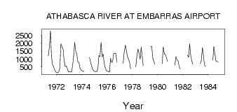
| ID | Year | Jan | Feb | Mar | Apr | May | Jun | Jul | Aug | Sep | Oct | Nov | Dec |
|---|---|---|---|---|---|---|---|---|---|---|---|---|---|
| 726 | 1971 | 1200.00 | 1700.00 | 2790.00 | 1180.00 | 654.00 | 536.00 | 325.00 | 199.00 | ||||
| 726 | 1972 | 143.00 | 134.00 | 212.00 | 450.00 | 1970.00 | 1770.00 | 1630.00 | 928.00 | 550.00 | 576.00 | 401.00 | 197.00 |
| 726 | 1973 | 237.00 | 200.00 | 181.00 | 551.00 | 1230.00 | 2060.00 | 1500.00 | 1360.00 | 813.00 | 790.00 | 470.00 | 322.00 |
| 726 | 1974 | 269.00 | 240.00 | 220.00 | 1110.00 | 826.00 | 584.00 | 378.00 | 257.00 | ||||
| 726 | 1975 | 229.00 | 198.00 | 216.00 | 436.00 | 1230.00 | 1150.00 | 2060.00 | 1130.00 | 1310.00 | 737.00 | 431.00 | 275.00 |
| 726 | 1976 | 243.00 | 219.00 | 182.00 | 1050.00 | 807.00 | 823.00 | 1380.00 | 1360.00 | 1380.00 | 795.00 | ||
| 726 | 1977 | 719.00 | 1420.00 | 1880.00 | 1550.00 | 1190.00 | 1000.00 | 793.00 | 391.00 | ||||
| 726 | 1978 | 497.00 | 1240.00 | 1640.00 | 1390.00 | 998.00 | 1760.00 | 1210.00 | 590.00 | ||||
| 726 | 1979 | 1780.00 | 1800.00 | 1070.00 | 884.00 | 663.00 | |||||||
| 726 | 1980 | 711.00 | 1770.00 | 1340.00 | 1290.00 | 1100.00 | 859.00 | ||||||
| 726 | 1981 | 626.00 | 1170.00 | 948.00 | 904.00 | 530.00 | 376.00 | ||||||
| 726 | 1982 | 1270.00 | 1100.00 | 1960.00 | 1180.00 | 876.00 | 679.00 | ||||||
| 726 | 1983 | 721.00 | 869.00 | 1730.00 | 1220.00 | 663.00 | 529.00 | ||||||
| 726 | 1984 | 940.00 | 1800.00 | 1270.00 | 845.00 | 855.00 | 818.00 |
 Return to R-Arctic Net Home Page