Sosva at Morozkovo
Ob
| PointID: | 7259 |
Code: | 12611 |
Latitude (decimal degrees): | 59.35 |
Longitude (decimal degrees): | 60.98 |
Drainage Area (km2): | 11500.00 |
Source: | SHI |
Hydrological Zone: | Ob |
Name: | Sosva at Morozkovo |
Field Definitions
Site Time Series Plot:
Site Data File:
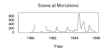
(Units: m3/s)
| ID | Year | Jan | Feb | Mar | Apr | May | Jun | Jul | Aug | Sep | Oct | Nov | Dec |
|---|
| 7259 | 1979 | | 16.20 | | | | 171.00 | | | 102.00 | | | |
| 7259 | 1980 | 24.20 | 12.70 | 12.00 | 97.00 | 376.00 | | | | | | 31.50 | 20.50 |
| 7259 | 1981 | 15.60 | 15.80 | | | 291.00 | 139.00 | 67.60 | 50.00 | 67.50 | 76.70 | 44.90 | 21.60 |
| 7259 | 1982 | 17.40 | 17.10 | 15.10 | 72.90 | 261.00 | 72.20 | 88.00 | 61.70 | 27.70 | 27.00 | 26.30 | 22.80 |
| 7259 | 1983 | 22.90 | 22.70 | 19.00 | 171.00 | 246.00 | 104.00 | 68.90 | 54.20 | 65.30 | 84.40 | 33.80 | 28.40 |
| 7259 | 1984 | 130.00 | 78.10 | 65.30 | 89.30 | 869.00 | 920.00 | 385.00 | 180.00 | 344.00 | 469.00 | 508.00 | 172.00 |
| 7259 | 1985 | 20.00 | 18.10 | 20.10 | 65.40 | 358.00 | 147.00 | 111.00 | 100.00 | 45.10 | 45.10 | 29.70 | 23.10 |
 Return to R-Arctic Net Home Page