Suklemka at Setovo
Ob
| PointID: | 7251 |
Code: | 12532 |
Latitude (decimal degrees): | 58.03 |
Longitude (decimal degrees): | 67.78 |
Drainage Area (km2): | 302.00 |
Source: | SHI |
Hydrological Zone: | Ob |
Name: | Suklemka at Setovo |
Field Definitions
Site Time Series Plot:
Site Data File:
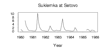
(Units: m3/s)
| ID | Year | Jan | Feb | Mar | Apr | May | Jun | Jul | Aug | Sep | Oct | Nov | Dec |
|---|
| 7251 | 1980 | 1.07 | 0.35 | 0.07 | | 6.06 | 3.08 | 2.06 | 0.68 | 0.46 | 0.41 | 0.39 | 0.31 |
| 7251 | 1981 | 0.18 | 0.18 | 0.15 | 1.46 | 10.30 | 4.82 | 2.26 | 1.27 | 0.54 | 0.36 | 0.29 | 0.19 |
| 7251 | 1982 | 0.08 | 0.03 | 0.02 | 1.11 | 3.08 | 1.84 | 0.74 | 0.37 | 0.21 | 0.32 | 0.61 | 0.45 |
| 7251 | 1983 | 0.38 | 0.42 | 0.27 | 3.70 | 7.09 | 2.78 | 1.18 | 0.58 | 0.29 | 0.48 | 0.38 | 0.23 |
| 7251 | 1984 | 0.19 | 0.11 | 0.17 | 0.38 | 2.07 | 1.24 | 0.12 | | | | | |
| 7251 | 1985 | | | | 0.59 | 1.08 | 0.91 | 0.19 | 0.04 | 0.70 | 0.55 | 0.46 | 0.12 |
 Return to R-Arctic Net Home Page