| PointID: | 721 | Code: | 07DB003 | Latitude (decimal degrees): | 56.85 | Longitude (decimal degrees): | -112.71 | Drainage Area (km2): | 1570.00 | Source: | Hydat | Hydrological Zone: | Mackenzie | Name: | DUNKIRK RIVER NEAR FORT MACKAY |
|---|
| Download | |
|---|---|
| Site Descriptor Information | Site Time Series Data |
| Link to all available data | |
| ID | Year | Jan | Feb | Mar | Apr | May | Jun | Jul | Aug | Sep | Oct | Nov | Dec |
|---|---|---|---|---|---|---|---|---|---|---|---|---|---|
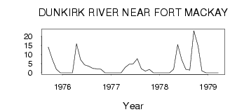
| 721 | 1975 | 14.10 | 7.38 | 2.00 | 0.00 | ||||||||
| 721 | 1976 | 0.00 | 0.00 | 0.00 | 16.00 | 7.26 | 4.35 | 3.60 | 2.45 | 2.21 | 1.98 | 0.00 | 0.00 |
| 721 | 1977 | 0.00 | 0.00 | 0.00 | 3.00 | 4.70 | 5.02 | 7.77 | 2.25 | 0.95 | 1.90 | 0.00 | 0.00 |
| 721 | 1978 | 0.00 | 0.00 | 0.00 | 2.00 | 15.50 | 7.23 | 1.97 | 1.46 | 23.10 | 14.80 | 1.00 | 0.00 |
| 721 | 1979 | 0.00 | 0.00 | 0.00 |
 Return to R-Arctic Net Home Page