Beshkilka at Shorohovo
Ob
| PointID: | 7208 |
Code: | 12225 |
Latitude (decimal degrees): | 56.65 |
Longitude (decimal degrees): | 65.37 |
Drainage Area (km2): | 68.19 |
Source: | SHI |
Hydrological Zone: | Ob |
Name: | Beshkilka at Shorohovo |
Field Definitions
Site Time Series Plot:
Site Data File:
(Units: m3/s)
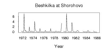
| ID | Year | Jan | Feb | Mar | Apr | May | Jun | Jul | Aug | Sep | Oct | Nov | Dec |
|---|
| 7208 | 1971 | | | | | | | | | | 0.17 | 0.27 | 0.19 |
| 7208 | 1972 | 0.05 | 0.04 | 0.05 | 7.09 | 1.36 | 0.48 | 0.27 | 0.57 | 0.09 | 0.11 | 0.05 | 0.07 |
| 7208 | 1973 | 0.09 | 0.08 | 0.03 | 1.96 | 0.38 | 0.08 | 0.14 | 0.07 | 0.28 | 0.29 | 0.06 | 0.05 |
| 7208 | 1974 | 0.06 | 0.07 | 0.04 | 4.12 | 1.17 | 0.79 | 0.26 | 0.13 | 0.06 | 0.06 | 0.05 | 0.03 |
| 7208 | 1975 | 0.03 | 0.06 | 0.08 | 1.32 | 0.23 | 0.09 | 0.10 | 0.10 | 0.09 | 0.08 | 0.05 | 0.05 |
| 7208 | 1976 | 0.04 | 0.04 | 0.06 | 0.58 | 0.20 | 0.07 | 0.11 | 0.09 | 0.08 | 0.10 | 0.07 | 0.04 |
| 7208 | 1977 | 0.04 | 0.04 | 0.04 | 1.31 | 0.25 | 0.08 | 0.07 | 0.08 | 0.08 | 0.07 | 0.06 | 0.05 |
| 7208 | 1978 | 0.04 | 0.02 | 0.12 | 0.33 | 0.23 | 0.07 | 0.05 | 0.06 | 0.08 | 0.18 | 0.11 | 0.06 |
| 7208 | 1979 | 0.07 | 0.07 | 0.08 | 1.54 | 3.35 | | 1.23 | | 0.20 | 0.24 | 0.19 | 0.12 |
| 7208 | 1980 | 0.07 | 0.06 | 0.04 | 7.14 | 1.90 | 0.69 | 0.15 | 0.11 | 0.07 | 0.09 | 0.07 | 0.06 |
| 7208 | 1981 | 0.07 | 0.06 | 0.06 | 3.67 | 2.67 | 0.39 | 0.13 | 0.05 | 0.07 | 0.05 | 0.05 | 0.05 |
| 7208 | 1982 | 0.06 | 0.07 | 0.05 | 0.52 | 0.57 | 0.48 | 0.05 | 0.06 | 0.06 | | | |
| 7208 | 1983 | | | | | 0.28 | 0.10 | 0.04 | 0.03 | 0.04 | 0.04 | 0.04 | 0.04 |
| 7208 | 1984 | 0.04 | 0.03 | 0.03 | 0.55 | 0.44 | 0.11 | 0.02 | 0.02 | 0.03 | 0.06 | | |
| 7208 | 1985 | 0.01 | 0.02 | | | 0.41 | 0.05 | 0.03 | 0.02 | 0.02 | 0.02 | 0.02 | 0.03 |
 Return to R-Arctic Net Home Page