Iset at Shadrinsk
Ob
| PointID: | 7183 |
Code: | 12125 |
Latitude (decimal degrees): | 56.08 |
Longitude (decimal degrees): | 63.63 |
Drainage Area (km2): | 23400.00 |
Source: | SHI |
Hydrological Zone: | Ob |
Name: | Iset at Shadrinsk |
Field Definitions
Site Time Series Plot:
Site Data File:
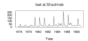
(Units: m3/s)
| ID | Year | Jan | Feb | Mar | Apr | May | Jun | Jul | Aug | Sep | Oct | Nov | Dec |
|---|
| 7183 | 1975 | | | | | | | | | | 7.87 | 4.38 | 4.04 |
| 7183 | 1976 | 3.34 | 5.27 | 7.39 | 47.40 | 14.50 | 7.83 | 8.17 | 10.70 | 10.70 | 9.42 | 9.90 | 6.38 |
| 7183 | 1977 | 4.98 | 5.24 | 5.98 | 34.00 | 29.90 | 17.70 | 9.51 | 8.27 | 8.79 | 7.75 | 7.94 | 6.42 |
| 7183 | 1978 | 5.53 | 4.17 | 7.33 | 21.90 | 14.40 | 13.90 | 34.00 | 23.40 | 20.00 | 20.00 | 21.60 | 14.40 |
| 7183 | 1979 | 10.60 | 11.80 | 10.10 | 78.40 | 168.00 | 33.40 | 18.20 | 14.30 | 13.30 | 12.60 | 12.40 | 12.20 |
| 7183 | 1980 | 8.85 | 8.46 | 9.64 | 163.00 | 104.00 | 61.70 | 33.30 | 21.80 | 22.50 | 27.90 | 24.00 | 14.10 |
| 7183 | 1981 | 15.00 | 10.90 | 11.30 | 157.00 | 118.00 | 60.50 | 21.70 | 14.40 | 13.80 | 15.00 | 14.30 | 11.10 |
| 7183 | 1982 | 10.70 | 10.10 | 10.70 | 49.70 | 24.50 | 23.00 | 14.40 | 15.50 | 16.40 | 18.80 | 19.60 | 16.60 |
| 7183 | 1983 | 12.90 | 12.70 | 17.60 | 182.00 | 42.50 | 21.00 | 18.90 | 20.40 | 31.20 | 40.30 | 20.50 | 14.60 |
| 7183 | 1984 | 14.40 | 9.13 | 12.90 | 63.70 | 54.10 | 44.60 | 21.90 | 43.80 | 28.80 | 59.50 | 53.20 | 21.40 |
| 7183 | 1985 | 15.90 | 17.20 | 20.40 | 266.00 | 116.00 | 47.20 | 23.40 | 28.10 | 18.30 | 19.30 | 13.80 | 17.50 |
| 7183 | 1986 | 15.00 | 11.10 | 14.50 | 208.00 | 100.00 | 35.90 | 56.90 | 42.10 | 38.90 | 59.60 | 70.10 | 26.70 |
| 7183 | 1988 | 24.10 | 18.30 | 22.30 | 141.00 | 133.00 | 56.60 | 21.10 | 20.30 | 24.40 | 20.40 | 22.10 | 17.50 |
 Return to R-Arctic Net Home Page