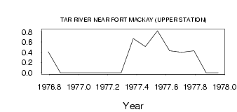
| PointID: | 718 | Code: | 07DA019 | Latitude (decimal degrees): | 57.48 | Longitude (decimal degrees): | -112.01 | Drainage Area (km2): | 103.00 | Source: | Hydat | Hydrological Zone: | Mackenzie | Name: | TAR RIVER NEAR FORT MACKAY (UPPER STATION) |
|---|
| Download | |
|---|---|
| Site Descriptor Information | Site Time Series Data |
| Link to all available data | |
| ID | Year | Jan | Feb | Mar | Apr | May | Jun | Jul | Aug | Sep | Oct | Nov | Dec |
|---|---|---|---|---|---|---|---|---|---|---|---|---|---|
| 718 | 1976 | 0.41 | 0.00 | 0.00 | |||||||||
| 718 | 1977 | 0.00 | 0.00 | 0.00 | 0.00 | 0.67 | 0.51 | 0.82 | 0.43 | 0.40 | 0.43 | 0.00 | 0.00 |
 Return to R-Arctic Net Home Page