Chuhonka at Markovo
Ob
| PointID: | 7177 |
Code: | 12102 |
Latitude (decimal degrees): | 56.50 |
Longitude (decimal degrees): | 66.50 |
Drainage Area (km2): | 16.79 |
Source: | SHI |
Hydrological Zone: | Ob |
Name: | Chuhonka at Markovo |
Field Definitions
Site Time Series Plot:
Site Data File:
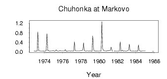
(Units: m3/s)
| ID | Year | Jan | Feb | Mar | Apr | May | Jun | Jul | Aug | Sep | Oct | Nov | Dec |
|---|
| 7177 | 1972 | | | | | | | | | | | 0.03 | 0.04 |
| 7177 | 1973 | 0.02 | 0.03 | 0.03 | 0.84 | 0.04 | 0.04 | 0.04 | 0.03 | 0.03 | 0.03 | 0.04 | 0.02 |
| 7177 | 1974 | 0.03 | 0.03 | 0.06 | 0.77 | 0.05 | 0.06 | 0.03 | 0.03 | 0.04 | 0.04 | 0.04 | 0.05 |
| 7177 | 1975 | 0.04 | 0.03 | 0.04 | 0.08 | 0.05 | 0.03 | 0.03 | 0.04 | 0.05 | 0.04 | 0.04 | 0.04 |
| 7177 | 1976 | 0.04 | 0.04 | 0.04 | 0.09 | 0.04 | 0.02 | 0.03 | 0.04 | 0.04 | 0.04 | 0.03 | 0.04 |
| 7177 | 1977 | 0.04 | 0.03 | 0.03 | 0.42 | 0.05 | 0.04 | 0.04 | 0.04 | 0.04 | 0.04 | 0.04 | 0.05 |
| 7177 | 1978 | 0.05 | 0.06 | 0.09 | 0.38 | 0.05 | 0.04 | 0.03 | 0.04 | 0.04 | 0.04 | 0.03 | 0.04 |
| 7177 | 1979 | 0.04 | 0.03 | 0.02 | 0.67 | 0.09 | 0.05 | 0.03 | 0.04 | 0.03 | 0.04 | 0.03 | 0.03 |
| 7177 | 1980 | 0.04 | 0.04 | 0.03 | 1.27 | 0.13 | 0.07 | 0.04 | 0.04 | 0.04 | 0.03 | 0.05 | 0.04 |
| 7177 | 1981 | 0.06 | 0.05 | 0.05 | 0.20 | 0.08 | 0.02 | | 0.03 | 0.04 | 0.03 | 0.03 | 0.03 |
| 7177 | 1982 | 0.03 | 0.03 | 0.03 | 0.42 | 0.02 | 0.05 | 0.07 | 0.03 | 0.04 | 0.04 | 0.03 | 0.03 |
| 7177 | 1983 | 0.04 | 0.06 | 0.07 | 0.32 | 0.05 | 0.04 | 0.03 | 0.03 | 0.04 | 0.03 | 0.03 | 0.04 |
| 7177 | 1984 | 0.03 | 0.04 | 0.03 | 0.29 | 0.06 | 0.04 | 0.02 | 0.03 | 0.04 | 0.04 | 0.04 | 0.04 |
| 7177 | 1985 | 0.04 | | | | | | | | | 0.02 | 0.02 | 0.02 |
 Return to R-Arctic Net Home Page