Toisay at Novopokrovka
Ob
| PointID: | 7171 |
Code: | 12086 |
Latitude (decimal degrees): | 53.80 |
Longitude (decimal degrees): | 65.30 |
Drainage Area (km2): | 82.00 |
Source: | SHI |
Hydrological Zone: | Ob |
Name: | Toisay at Novopokrovka |
Field Definitions
Site Time Series Plot:
Site Data File:
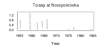
(Units: m3/s)
| ID | Year | Jan | Feb | Mar | Apr | May | Jun | Jul | Aug | Sep | Oct | Nov | Dec |
|---|
| 7171 | 1955 | | | | 0.76 | 0.13 | | | | | | | |
| 7171 | 1956 | | | | 0.57 | | | | | | | | |
| 7171 | 1959 | | | | 1.40 | 0.04 | | | | | | | |
| 7171 | 1960 | | | | 0.69 | | | | | | | | |
| 7171 | 1961 | | | 0.34 | 0.38 | | | | | | | | |
| 7171 | 1962 | | | 0.60 | 0.56 | 0.01 | | | | | | | |
| 7171 | 1963 | | | | 0.42 | | | | | | | | |
| 7171 | 1964 | | | | 0.73 | 0.19 | | | | | | | |
| 7171 | 1966 | | | | 0.85 | 0.06 | | | | | | | |
| 7171 | 1967 | | | | 0.41 | | | | | | | | |
| 7171 | 1968 | | | | 0.02 | | | | | | | | |
| 7171 | 1970 | | | | 0.67 | | | | | | | | |
| 7171 | 1975 | | | 1.0e-03 | 0.08 | | | | | | | | |
| 7171 | 1977 | | | 0.01 | 0.22 | | | | | | | | |
| 7171 | 1978 | | | 0.04 | | | | | | | | | |
| 7171 | 1981 | | | | 0.08 | | | | | | | | |
| 7171 | 1984 | | | 4.0e-03 | 0.04 | 2.0e-03 | | | | | | | |
 Return to R-Arctic Net Home Page